ไฟล์:1730 C. Homann Map of Asia - Geographicus - Asiae-homann-1730.jpg

ไม่รองรับเนื้อหาของหน้าในภาษาอื่น
จากวิกิพีเดีย สารานุกรมเสรี

ดูภาพที่มีความละเอียดสูงกว่า(4,000 × 3,492 พิกเซล, ขนาดไฟล์: 5.26 เมกะไบต์, ชนิดไมม์: image/jpeg)

Wikimedia Commons logo รูปภาพหรือไฟล์เสียงนี้ ต้นฉบับอยู่ที่ คอมมอนส์ รายละเอียดด้านล่าง เป็นข้อความที่แสดงผลจาก ไฟล์ต้นฉบับในคอมมอนส์
คอมมอนส์เป็นเว็บไซต์ในโครงการสำหรับเก็บรวบรวมสื่อเสรี ที่ คุณสามารถช่วยได้

ความย่อ

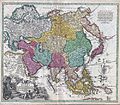
Johann Christoph Homann: Recentissima Asiae Delineatio : Qua Imperia, eius Regna, et Status, Unacum novissimis Russorum detectionibus circa Mare Caspium et Terram Yedso alias dict. per illor. Expedit. et Excursiones, factis sistuntur.   (Wikidata search (Cirrus search) Wikidata query (SPARQL)  Create new Wikidata item based on this file)
ศิลปิน/ผู้สร้างสรรค์งาน
Johann Christoph Homann  (1703–1730)  wikidata:Q18508380
 
คำอธิบาย German physician, publisher และ cartographer
วันเกิด/วันเสียชีวิต 2245 หรือ 2246 แก้ไขที่วิกิสนเทศ 2272 หรือ 2273 แก้ไขที่วิกิสนเทศ
สถานที่เกิด/สถานที่เสียชีวิต เนือร์นแบร์ค เนือร์นแบร์ค
สถานที่สร้างสรรค์งาน
งานควบคุมรายการหลักฐาน
artist QS:P170,Q18508380
ชื่อเรื่อง
Recentissima Asiae Delineatio : Qua Imperia, eius Regna, et Status, Unacum novissimis Russorum detectionibus circa Mare Caspium et Terram Yedso alias dict. per illor. Expedit. et Excursiones, factis sistuntur.
คำอธิบาย
English: A rare and attractive 18th century map of Asia by German map publisher Johann Christoph Homann. Covers the entire continent of Asia as well as parts of Europe and northeastern Africa. This is essentially a revised and updated version of J. B. Homann’s 1712 map of Asia. Features some interesting and important updates. Most notably, we see the addition of the Kamchatka Peninsula in the upper right hand quadrant. The lower part of the peninsula is labeled “Kurilorum Regio”, no doubt an early reference to the Kuril Islands. While Hokkaido is not present, Japan itself is separated from the mainland by a small archipelago. Just east of these islands we see the Canal de Piecko, and beyond that a large and curious land mass labeled Compagnie Land. Compagnie Land is a mythical landmass that can be traced the work of an unknown Spanish pilot who supposedly traveled from China to New Span and published his finding along with the works of Thevenot. Present in both the 1712 map and this one, Compagnie’s Land could possibly be an early representation of Alaska or a misrepresentation of Hokkaido. Korea or Corea is present if misshapen in roughly the correct location. Further south New Guinea, New Britannia, Australia (New Holland), Hoch Land, and Carpentaria (part of Australia) are personated in tentative form with largely unexplored boundaries. At the center of the map the Caspian Sea is displayed according to the 1722 surveys of Karl van Verden. Bottom left quadrant features a decorative title cartouche displaying an enthroned king in Middle Eastern or Indian garb, exotic animals including a lion and leopard, trade goods, Camels, and bowing supplicants. A spectacular and important 18th century map of Asia.
วันที่ circa 2272 หรือ 2273
date QS:P571,+1730-00-00T00:00:00Z/9,P1480,Q5727902
(undated)
ขนาด ความสูง: ๑๙.๕ in (๔๙.๕ cm); ความกว้าง: ๒๒.๕ in (๕๗.๑ cm)
dimensions QS:P2048,19.5U218593
dimensions QS:P2049,22.5U218593
รหัสการถึอครอง
Geographicus link: Asiae-homann-1730
ที่มา/ผู้ถ่ายภาพ
การอนุญาต
(การใช้ไฟล์นี้ใหม่)
ภาพนี้เป็นภาพที่เกิดจากการทำสำเนาภาพหรือศิลปกรรมสองมิติ ซึ่งตัวภาพต้นฉบับที่ถูกทำซ้ำนั้นเป็นสาธารณสมบัติด้วยเหตุผลต่อไปนี้
Public domain

งานนี้เป็นสาธารณสมบัติ ในประเทศต้นกำเนิดและประเทศอื่น ๆ ที่ระยะเวลาการคุ้มครองลิขสิทธิ์น้อยกว่า 100 ปีหลังจากผู้สร้างสรรค์งานเสียชีวิต.


นอกจากนี้คุณอาจต้องเพิ่มป้ายสาธารณสมบัติในสหรัฐอเมริกา เพื่อระบุว่าเหตุใดงานนี้จึงเป็นสาธารณสมบัติในสหรัฐอเมริกา
มูลนิธิวิกิพีเดียมีมุมมองอย่างเป็นทางการในกรณีนี้ว่า "การทำสำเนาภาพหรือศิลปกรรมสองมิติที่เป็นสาธารณสมบัติ ถือว่าภาพที่ได้จากการทำสำเนาเป็นสาธารณสมบัติ การอ้างผลงานดังกล่าวเป็นงานส่วนบุคคลเป็นการขัดต่อแนวคิดเกี่ยวกับสาธารณสมบัติ" สำหรับข้อมูลเพิ่มเติม ดูที่ เมื่อใดจะใช้ป้าย PD-Art
การทำสำเนาของภาพนี้ซึ่งเป็นสาธารณสมบัติ ถือได้ว่าภาพที่เกิดจากการทำสำเนาเป็นสาธารณสมบัติเช่นกัน โปรดทราบว่าการนำภาพนี้ไปใช้อาจถูกจำกัดหรือห้ามใช้ในเขตอำนาจศาลของท่าน ทั้งนี้ขึ้นกับกฎหมายท้องถิ่นที่บังคับใช้ในพื้นที่นั้น ๆ ดูเพิ่มที่ การนำภาพหรือศิลปกรรมสองมิติไปใช้

คำบรรยายโดยย่อ

เพิ่มคำบรรยายทรรทัดเดียวเพื่อขยายความว่าไฟล์นี้มีอะไร
A rare and attractive 18th century map of Asia by German map publisher Johann Christoph Homann.

ไอเทมที่แสดงอยู่ในไฟล์นี้

ประกอบด้วย

MIME type อังกฤษ

image/jpeg

checksum อังกฤษ

50d7f41d7c194c9d50a804aaa1b6cba16d8c371b

data size อังกฤษ

5,516,217 ไบต์

3,492 พิกเซล

4,000 พิกเซล

ประวัติไฟล์

คลิกวันที่/เวลาเพื่อดูไฟล์ที่ปรากฏในขณะนั้น

วันที่/เวลารูปย่อขนาดผู้ใช้ความเห็น
ปัจจุบัน23:35, 16 มีนาคม 2554รูปย่อสำหรับรุ่นเมื่อ 23:35, 16 มีนาคม 25544,000 × 3,492 (5.26 เมกะไบต์)BotMultichill{{subst:User:Multichill/Geographicus |link=http://www.geographicus.com/P/AntiqueMap/Asiae-homann-1730 |product_name=1730 C. Homann Map of Asia |map_title=Recentissima Asiae Delineatio : Qua Imperia, eius Regna, et Status, Unacum novissimis Russorum detect

หน้าต่อไปนี้ โยงมาที่ภาพนี้:

การใช้ไฟล์ข้ามโครงการ

วิกิอื่นต่อไปนี้ใช้ไฟล์นี้: