
ไฟล์:16-07-06-Rathaus Graz Turmblick-RR2 0275.jpg
ดูภาพที่มีความละเอียดสูงกว่า (4,288 × 2,848 พิกเซล, ขนาดไฟล์: 9.76 เมกะไบต์, ชนิดไมม์: image/jpeg)
| รูปภาพหรือไฟล์เสียงนี้ ต้นฉบับอยู่ที่ คอมมอนส์ รายละเอียดด้านล่าง เป็นข้อความที่แสดงผลจาก ไฟล์ต้นฉบับในคอมมอนส์
|
ความย่อ
| คำอธิบาย |
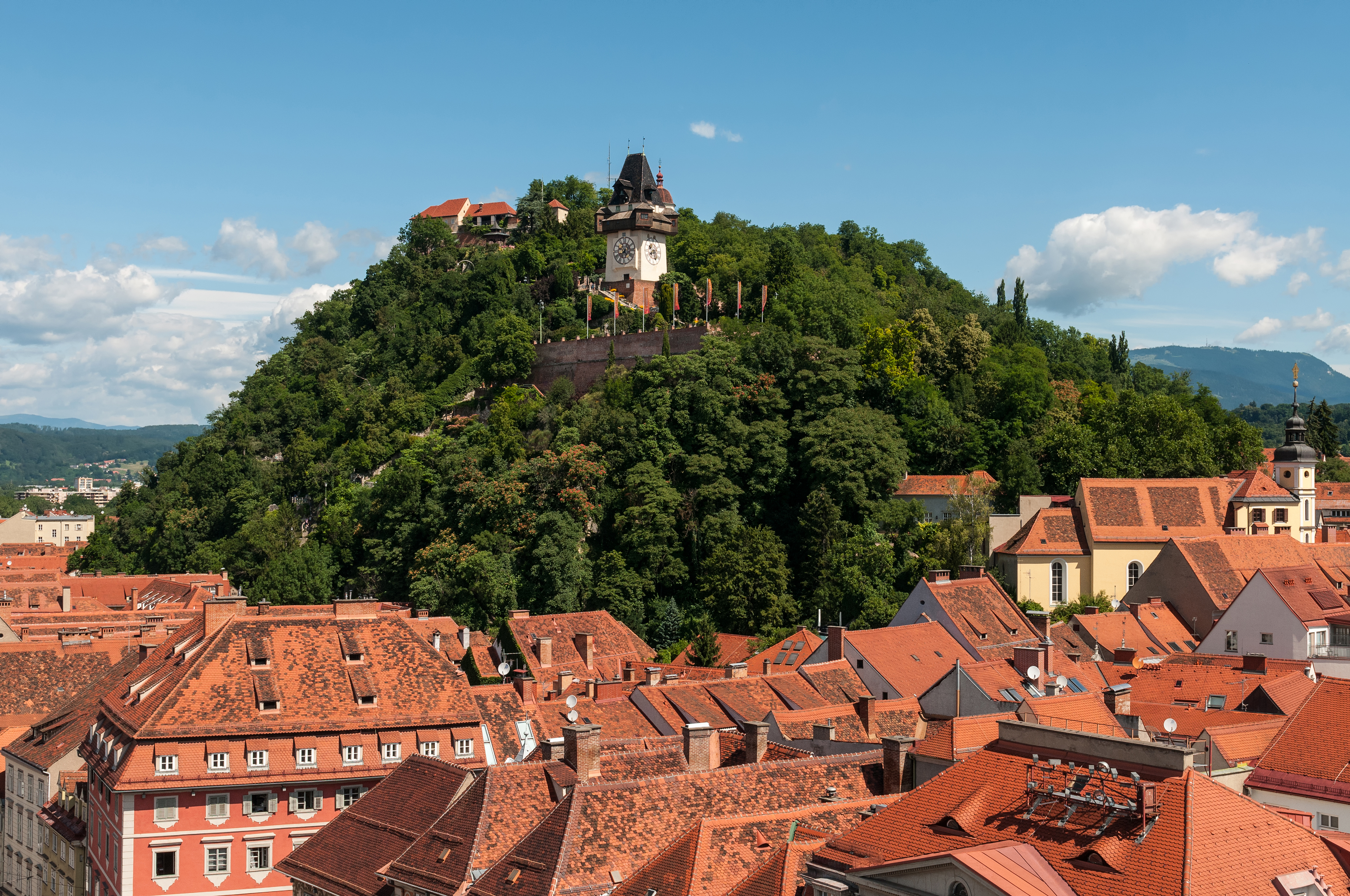
Deutsch: Schloßberg Graz, Blick von der Turmspitze des Rathauses
Čeština: Štýrský Hradec, pohled z věže radnice
Català: Castell del Pujol Graz, vista des de la torre de l'ajuntament
Español: Castillo de la Colina Graz, vista desde la torre del ayuntamiento
Русский: Шлоссберг Грац, Вид с башни ратуши
English: Castle mountain Graz, view from the spire of the town hall
|
|||||||||||||||||||||||
| วันที่ | ||||||||||||||||||||||||
| แหล่งที่มา | งานของตัว | |||||||||||||||||||||||
| ผู้สร้างสรรค์ |
|
|||||||||||||||||||||||
| การอนุญาต (การใช้ไฟล์นี้ใหม่) |
|
|||||||||||||||||||||||


| ตำแหน่งที่ตั้งกล้อง | | ภาพนี้และภาพอื่น ๆ ณ สถานที่เดียวกันที่ OpenStreetMap |
|---|
| ตำแหน่งของวัตถุหรือสถานที่ | | ภาพนี้และภาพอื่น ๆ ณ สถานที่เดียวกันที่ OpenStreetMap |
|---|
Assessment
|
ภาพนี้ได้รับการคัดสรรให้เป็น ภาพประจำวัน สำหรับวันที่ 6 กรกฎาคม พ.ศ. 2566 ภาพดังกล่าวมีคำอธิบายดังต่อไปนี้: English: Castle mountain Graz, view from the spire of the town hall. ภาษาอื่น ๆ:
Čeština: Mohutná skála Schloßberg nad rakouským Štýrským Hradcem (Gratzem), z jehož radniční věže byl nafotografován tento snímek. Deutsch: Der Grazer Schloßberg. English: Castle mountain Graz, view from the spire of the town hall. Español: Schloßberg, vista desde la torre del ayuntamiento. Français : Le Schloßberg, colline de Graz (Autriche) abritant un jardin public et une forteresse. Vue ici depuis la tour de l'hôtel de ville. Italiano: Vista del monte castello di Graz dalla guglia del municipio, nella città di Graz in Austria. Nederlands: Blik op de Uhrturm op de Schlossberg in Graz, de hoofdstad van de Oostenrijkse deelstaat Stiermarken Português: Montanha do castelo em Graz, Áustria, vista da torre da prefeitura. |
|
|
Wikipedia-Landtagsprojekt/Steiermark 20165. of July 2016 in Graz More than 10 persons participated in this project voluntarily and without expense allowance.
|
|
 |
Usage informationIf you need more information how to use this file, please send an |
|
The making of this work was supported by Wikimedia Austria. For other files made with the support of Wikimedia Austria, please see the category Supported by Wikimedia Österreich. |
The making of this document was supported by Skillshare.
To see other files made with the support of Skillshare, please see the category Supported by Skillshare. |
- คุณสามารถ:
- ที่จะแบ่งปัน – ที่จะทำสำเนา แจกจ่าย และส่งงานดังกล่าวต่อไป
- ที่จะเรียบเรียงใหม่ – ที่จะดัดแปลงงานดังกล่าว
- ภายใต้เงื่อนไขต่อไปนี้:
- แสดงที่มา – คุณต้องให้เกียรติเจ้าของงานอย่างเหมาะสม โดยเพิ่มลิงก์ไปยังสัญญาอนุญาต และระบุหากมีการเปลี่ยนแปลง คุณอาจทำเช่นนี้ได้ในรูปแบบใดก็ได้ตามควร แต่ต้องไม่ใช่ในลักษณะที่แนะว่าผู้ให้อนุญาตสนับสนุนคุณหรือการใช้งานของคุณ
- อนุญาตแบบเดียวกัน – หากคุณดัดแปลง เปลี่ยนรูป หรือต่อเติมงานนี้ คุณต้องใช้สัญญาอนุญาตแบบเดียวกันหรือแบบที่เหมือนกับสัญญาอนุญาตที่ใช้กับงานนี้เท่านั้น

การอนุญาตใช้สิทธิ

|
อนุญาตให้คัดลอก แจกจ่ายและ/หรือแก้ไขเอกสารนี้ภายใต้เงื่อนไขของสัญญาอนุญาตเอกสารเสรีของกนู รุ่น 1.2 นี้ที่ออกโดยมูลนิธิซอฟต์แวร์เสรี โดยไม่มีส่วนใดห้ามแก้ไข ไม่มีข้อความปกหน้าและปกหลัง สำเนาของสัญญาอนุญาตรวมอยู่ในส่วนชื่อ สัญญาอนุญาตเอกสารเสรีของกนู | 1.2 เท่านั้น |
ประวัติไฟล์
คลิกวันที่/เวลาเพื่อดูไฟล์ที่ปรากฏในขณะนั้น
| วันที่/เวลา | รูปย่อ | ขนาด | ผู้ใช้ | ความเห็น | |
|---|---|---|---|---|---|
| ปัจจุบัน | 05:45, 9 กรกฎาคม 2559 | | 4,288 × 2,848 (9.76 เมกะไบต์) | Ralf Roletschek | sky denoised |
| 03:26, 9 กรกฎาคม 2559 |  | 4,288 × 2,848 (10.28 เมกะไบต์) | Ralf Roletschek |
หน้าที่มีภาพนี้
หน้าต่อไปนี้ โยงมาที่ภาพนี้:
การใช้ไฟล์ข้ามโครงการ
วิกิอื่นต่อไปนี้ใช้ไฟล์นี้:
- การใช้บน am.wikipedia.org
- การใช้บน an.wikipedia.org
- การใช้บน ar.wikipedia.org
- การใช้บน arz.wikipedia.org
- การใช้บน ast.wikipedia.org
- การใช้บน av.wikipedia.org
- การใช้บน az.wikipedia.org
- การใช้บน ban.wikipedia.org
- การใช้บน ba.wikipedia.org
- การใช้บน be-tarask.wikipedia.org
- การใช้บน bg.wikipedia.org
- การใช้บน bn.wikipedia.org
- การใช้บน ca.wikipedia.org
- การใช้บน ceb.wikipedia.org
- การใช้บน ce.wikipedia.org
- การใช้บน cs.wikipedia.org
- การใช้บน cv.wikipedia.org
- การใช้บน cy.wikipedia.org
- การใช้บน de.wikipedia.org
- Österreich
- Belagerung von Graz
- Wikipedia:Landtagsprojekt/Steiermark/Locations
- Wikipedia Diskussion:Hauptseite/Artikel des Tages/Archiv/Vorschläge/2018/Q1
- Wikipedia:Hauptseite/Archiv/13. März 2018
- Portal:Österreich/RegiowikiAT Redundanzen
- Benutzerin:Alfonsina2019
- Liste der denkmalgeschützten Objekte in Graz/Innere Stadt/O–Z
- Wikipedia:WikiProjekt Österreich/checks/Denkmalschutz/WP - WD diffs 02
- การใช้บน de.wikiversity.org
- การใช้บน de.wikivoyage.org
- การใช้บน de.wiktionary.org
- การใช้บน el.wikipedia.org
- การใช้บน en.wikipedia.org
- การใช้บน en.wikivoyage.org
- การใช้บน eo.wikipedia.org
- การใช้บน eo.wikivoyage.org
- การใช้บน eu.wikipedia.org
- การใช้บน fa.wikipedia.org
- การใช้บน fi.wikipedia.org
ดูการใช้ข้ามโครงการเพิ่มเติมของไฟล์นี้