
แผนที่รูปทีและโอ

แผนที่รูปทีและโอ (อังกฤษ: T and O map หรือ O-T หรือ T-O; ละติน: orbis terrarum ลูกแก้วหรือวงกลมของผืนดินที่มีอักษร T ใน O) เป็นหนึ่งในแผนที่โลกในยุคกลาง บางครั้งมันถูกเรียกว่า แผนที่บีไทน์ (Beatine map) หรือแผนที่บีตุส (Beatus map) เพราะเป็นหนึ่งในผลงานที่เชื่อว่าเป็นของบีตุส แห่งเลียบานา (Beatus of Liébana) นักบวชชาวสเปนในศตวรรษที่ 8
ประวัติและรายละเอียด[แก้]
แผนที่รูปทีและโอถูกกล่าวครั้งแรกในหนังสือ Etymologiae (chapter 14, de terra et partibus) ของอิซิโดโรแห่งเซบิยาในศตวรรษที่ 7 ไว้ว่า:
ละติน: Orbis a rotunditate circuli dictus, quia sicut rota est [...] Undique enim Oceanus circumfluens eius in circulo ambit fines. Divisus est autem trifarie: e quibus una pars Asia, altera Europa, tertia Africa nuncupatur. อังกฤษ: The [inhabited] mass of solid land is called round after the roundness of a circle, because it is like a wheel [...] Because of this, the Ocean flowing around it is contained in a circular limit, and it is divided in three parts, one part being called Asia, the second Europe, and the third Africa. [1]
แปลไทย: ผืนดิน[ที่อยู่อาศัย]ถูกกล่าวเป็นรูปกลมตามความกลมของรูปวงกลม เพราะมันดูเหมือนล้อ [...] เพราะอย่างนี้ มหาสมุทรที่อยู่รอบมันจะอยู่ในขอบวงกลม และถูกแบ่งเป็นสามส่วน ส่วนหนึ่งคือเอเชีย ส่วนที่สองคือยุโรป และส่วนที่สามคือแอฟริกา
ถึงแม้ว่าอิซิโดโรกล่าวใน Etymologiae ว่าโลก "กลม" ในความหมายของเขานั้นยังคลุมเครือ และนักเขียนบางคนกล่าวว่าเขาหมายถึงโลกรูปจาน (disc-shaped Earth). แต่อย่างไรก็ตาม นักเขียนบางคนกล่าวว่าเขาหมายถึงโลกที่กลมเหมือนลูกโลก (globular)[2]


แผนที่รูปทีและโอแสดงแค่ครึ่งหนึ่งของโลกทรงกลมทั้งหมด[3] จึงมีความเชื่อว่าไม่มีใครสามารถข้ามไปอีกเส้นขอบหนึ่งได้.[3][4]
ตัว T คือทะเลเมดิเตอร์เรเนียน, แม่น้ำไนล์ และแม่น้ำดอน (อดีตอ้างถึงเมืองตาไนส Tanais) ที่แบ่งสามทวีป คือทวีปเอเชีย, ยุโรป และแอฟริกา ส่วนตัว O คือมหาสมุทร โดยมีกรุงเยรูซาเลมเป็นศูนย์กลางของแผนที่ ทวีปเอเชียมีขนาดใหญ่เป็นสองเท่าของทวีปที่เหลือรวมกัน เพราะดวงอาทิตย์ขึ้นทางทิศตะวันออก, สวรรค์ (สวนอีเดน) มักถูกตั้งในเอเชีย และทวีปเอเชียถูกตั้งไว้ด้านบนสุดของแผนที่
ภาพ[แก้]
-
 แผนที่ยุคกลางที่ถูกบูรณะใหม่ (จาก Meyers Konversationslexikon, 1895) (เอเชียอยู่ด้านขวา)
 -
 แผนที่โลกจาก Saint-Sever Beatus, วาดไว้ประมาณ ค.ศ.1050
 -
 แผนที่ที่มีศูนย์กลางอยู่ที่ Delos ตามธรรมเนียมของกรีก จากเอกสารภาษาฝรั่งเศสของ Henry of Huntingdon, ปลายศตวรรษที่ 13
 -
 Mappa Mundi ใน
La Fleur des Histoires ค.ศ. 1459-1463 -
 Bünting Clover Leaf Map ภาพสลักไม้ในปี ค.ศ.1581, Magdeburg
เยรูซาเลมตั้งอยู่ตรงกลาง ล้อมรอบด้วยยุโรป, เอเชีย และแอฟริกา -
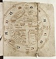
 ภาพด้านขวาของเอกสารเป็นแผนที่รูปทีและโอ โดย Jacobus Philippus Bergomensis (Giacomo Filippo Foresti) ค.ศ. 1503
 -


ดูเพิ่ม[แก้]
อ้างอิง[แก้]
- ↑ Isidore of Seville (c. 630). "14". Etymologiae (ภาษาละติน).
- ↑ Stevens, Wesley M. (1980). "The Figure of the Earth in Isidore's 'De natura rerum'". Isis. 71 (2): 268–277. doi:10.1086/352464. JSTOR 230175.
- ↑ 3.0 3.1 Michael Livingston, Modern Medieval Map Myths: The Flat World, Ancient Sea-Kings, and Dragons เก็บถาวร 2006-02-09 ที่ เวย์แบ็กแมชชีน, 2002.
- ↑ Hiatt, Alfred (2002). "Blank Spaces on the Earth". The Yale Journal of Criticism. 15 (2): 223–250. doi:10.1353/yale.2002.0019.
บรรณานุกรม[แก้]
- Crosby, Alfred W. (1996). The Measure of Reality: Quantification in Western Europe, 1250-1600. Cambridge: Cambridge University Press. ISBN 0-521-55427-6.
- Lester, Toby (2009). The fourth part of the world: the race to the ends of the Earth, and the epic story of the map that gave America its name. New York, NY: Free Press. ISBN 9781416535317.
- Carlo Zaccagnini, ‘Maps of the World’, in Giovanni B. Lanfranchi et al., Leggo! Studies Presented to Frederick Mario Fales on the occasion of his 65th birthday, Wiesbaden, Harrassowitz Verlag, 2012, pp. 865–874. ISBN 9783447066594
- Mode, PJ. "The History and Academic Literature of Persuasive Cartography". Persuasive Cartography, The PJ Mode Collection. Cornell University Library. สืบค้นเมื่อ 22 October 2015.
- Brigitte Englisch, Ordo orbis terrae. Die Weltsicht in den Mappae mundi des frühen und hohen Mittelalters. Berlin 2002, ISBN 3-05-003635-4