
ผลต่างระหว่างรุ่นของ "ผู้ใช้:Waniosa Amedestir/ทดลองเขียน 2"
ไม่มีความย่อการแก้ไข ป้ายระบุ: เครื่องมือแก้ไขต้นฉบับปี 2560 |
ป้ายระบุ: เครื่องมือแก้ไขต้นฉบับปี 2560 |
||
| บรรทัด 1,304: | บรรทัด 1,304: | ||
===2010 census=== |
===2010 census=== |
||
As of the [[census]]<ref name="wwwcensusgov">{{cite web|title=U.S. Census website|url=https://www.census.gov|publisher=[[United States Census Bureau]]|access-date=November 13, 2012}}</ref> of 2010, there were 38,065 people, 14,304 households, and 8,372 families living in the city. The [[population density]] was {{convert|1922.5|PD/sqmi|PD/km2|1}}. There were 15,274 housing units at an average density of {{convert|771.4|/sqmi|/km2|1}}. The racial makeup of the city was 90.7% [[White (U.S. Census)|White]], 2.0% [[African American (U.S. Census)|African American]], 1.5% [[Native American (U.S. Census)|Native American]], 2.0% [[Asian (U.S. Census)|Asian]], 1.1% from [[Race (U.S. Census)|other races]], and 2.6% from two or more races. [[Hispanic (U.S. Census)|Hispanic]] or [[Latino (U.S. Census)|Latino]] of any race were 4.1% of the population. |
As of the [[census]]<ref name="wwwcensusgov">{{cite web|title=U.S. Census website|url=https://www.census.gov|publisher=[[United States Census Bureau]]|access-date=November 13, 2012}}</ref> of 2010, there were 38,065 people, 14,304 households, and 8,372 families living in the city. The [[population density]] was {{convert|1922.5|PD/sqmi|PD/km2|1}}. There were 15,274 housing units at an average density of {{convert|771.4|/sqmi|/km2|1}}. The racial makeup of the city was 90.7% [[White (U.S. Census)|White]], 2.0% [[African American (U.S. Census)|African American]], 1.5% [[Native American (U.S. Census)|Native American]], 2.0% [[Asian (U.S. Census)|Asian]], 1.1% from [[Race (U.S. Census)|other races]], and 2.6% from two or more races. [[Hispanic (U.S. Census)|Hispanic]] or [[Latino (U.S. Census)|Latino]] of any race were 4.1% of the population. |
||
There were 14,304 households, of which 29.4% had children under the age of 18 living with them, 43.5% were [[Marriage|married couples]] living together, 10.6% had a female householder with no husband present, 4.4% had a male householder with no wife present, and 41.5% were non-families. 29.2% of all households were made up of individuals, and 10% had someone living alone who was 65 years of age or older. The average household size was 2.41 and the average family size was 2.97. |
|||
The median age in the city was 28.3 years. 20.9% of residents were under the age of 18; 23.7% were between the ages of 18 and 24; 23.4% were from 25 to 44; 20.5% were from 45 to 64; and 11.5% were 65 years of age or older. The gender makeup of the city was 48.4% male and 51.6% female. |
|||
===2000 census=== |
===2000 census=== |
||
As of the [[census]] of 2000, there were 32,177 people, 11,660 households, and 7,030 families living in the city. The [[population density]] was 2,394.3 people per square mile (924.4/km{{sup|2}}). There were 12,180 housing units at an average density of 906.3 per square mile (349.9/km{{sup|2}}). The racial makeup of the city was 92.08% [[White (U.S. Census)|White]], 0.77% [[African American (U.S. Census)|African American]], 1.94% [[Native American (U.S. Census)|Native American]], 1.27% [[Asian (U.S. Census)|Asian]], 0.04% [[Pacific Islander (U.S. Census)|Pacific Islander]], 2.10% from [[Race (United States Census)|other races]], and 1.79% from two or more races. [[Hispanic (U.S. Census)|Hispanic]] or [[Latino (U.S. Census)|Latino]] of any race were 4.47% of the population. |
As of the [[census]] of 2000, there were 32,177 people, 11,660 households, and 7,030 families living in the city. The [[population density]] was 2,394.3 people per square mile (924.4/km{{sup|2}}). There were 12,180 housing units at an average density of 906.3 per square mile (349.9/km{{sup|2}}). The racial makeup of the city was 92.08% [[White (U.S. Census)|White]], 0.77% [[African American (U.S. Census)|African American]], 1.94% [[Native American (U.S. Census)|Native American]], 1.27% [[Asian (U.S. Census)|Asian]], 0.04% [[Pacific Islander (U.S. Census)|Pacific Islander]], 2.10% from [[Race (United States Census)|other races]], and 1.79% from two or more races. [[Hispanic (U.S. Census)|Hispanic]] or [[Latino (U.S. Census)|Latino]] of any race were 4.47% of the population. |
||
There were 11,660 households, out of which 31.4% had children under the age of 18 living with them, 47.3% were [[Marriage|married couples]] living together, 9.8% had a female householder with no husband present, and 39.7% were non-families. 29.2% of all households were made up of individuals, and 11.1% had someone living alone who was 65 years of age or older. The average household size was 2.43 and the average family size was 3.04. |
|||
In the city, the population was spread out, with 22.7% under the age of 18, 23.1% from 18 to 24, 24.2% from 25 to 44, 17.2% from 45 to 64, and 12.8% who were 65 years of age or older. The median age was 29 years. For every 100 females, there were 88.4 males. For every 100 females age 18 and over, there were 83.3 males. |
|||
The median income for a household in the city was $34,781, and the median income for a family was $49,118. Males had a median income of $33,137 versus $23,717 for females. The [[per capita income]] for the city was $17,150. About 8.2% of families and 16.3% of the population were below the [[poverty line]], including 14.9% of those under age 18 and 6.4% of those age 65 or over. |
|||
==References== |
==References== |
||
รุ่นแก้ไขเมื่อ 11:59, 22 กรกฎาคม 2564
 | นี่คือหน้าทดลองเขียนของ Waniosa Amedestir หน้าทดลองเขียนเป็นหน้าย่อยของหน้าผู้ใช้ ซึ่งผู้ใช้มีไว้ทดลองเขียนหรือไว้พัฒนาหน้าต่าง ๆ แต่นี่ไม่ใช่หน้าบทความสารานุกรม ทดลองเขียนได้ที่นี่ หน้าทดลองเขียนอื่น ๆ: หน้าทดลองเขียนหลัก |
เขตตาเวา

Tawau Division (มลายู: Bahagian Tawau) is one of the five administrative sub-divisions of Sabah, Malaysia. It occupies a total of 14,905 square kilometres or 20% of Sabah's territory.[1] The main towns include the capital of Tawau, Lahad Datu, Kunak and Semporna. Tawau division has 26% of Sabah's total population,[1] with the main indigenous groups consisting of the Bajau, Suluk, Ida'an, Tidong, Cocos, Murut, Lun Bawang/Lun Dayeh as well as a minority of mixed ethnic groups.[2][3] Large numbers of both legal and illegal immigrants from Indonesia such as the Buginese and Torajans, from East Timor the Timorese,[4] from the Philippines the Tausūg and Visayans as well South and West Asian immigrants such as Pakistanis, Indians and Arabs can be found in this area.[2] As with the rest of Sabah, the division also has large numbers of ethnic Chinese.[3]
Tawau port is the third largest port after Kota Kinabalu and Sandakan. The port serves as a major timber and agricultural products export centre.[5] There are two domestic airports serving the Tawau division: one in Tawau and one in Lahad Datu.[1] The division includes the islands of Sipadan and Ligitan, as well as the northern half of Sebatik Island (the southern half lies within Indonesia). It also includes Tawau Hills Park.
อำเภอ
Tawau Division is subdivided into the following administrative districts:[1]
- Kalabakan District (3,885 km2[6]) (Kalabakan Town)
- Kunak District (1,134 km2) (Kunak Town)
- Lahad Datu District (6,501 km2) (Lahad Datu Town)
- Semporna District (1,145 km2) (Semporna Town)
- Tawau District (2,240 km2[6]) (Tawau Town)
Kalabakan District was split from Tawau District on 1 January 2019.[7][8]
Notes
Literature
- Tregonning, K. G. (1965). A History Of Modern Sabah (North Borneo 1881–1963). University of Malaya Press.
References
- ↑ 1.0 1.1 1.2 1.3 "General Information". Lands and Surveys Department of Sabah. Borneo Trade. สืบค้นเมื่อ 1 พฤศจิกายน 2017.
- ↑ 2.0 2.1 Victor T. King; Zawawi Ibrahim; Noor Hasharina Hassan (12 สิงหาคม 2016). Borneo Studies in History, Society and Culture. Springer Singapore. pp. 239–. ISBN 978-981-10-0672-2.
- ↑ 3.0 3.1 Peter Chay (1 มกราคม 1988). Sabah: the land below the wind. Foto Technik. ISBN 978-967-9981-12-4.
- ↑ Geoffrey C. Gunn (18 ธันวาคม 2010). Historical Dictionary of East Timor. Scarecrow Press. pp. 71–. ISBN 978-0-8108-7518-0.
- ↑ Tamara Thiessen (5 มกราคม 2016). Borneo. Bradt Travel Guides. pp. 239–. ISBN 978-1-84162-915-5.
- ↑ 6.0 6.1 "Statistics Yearbook Sabah 2019". Department of Statistics, Malaysia. ธันวาคม 2020. p. 3. สืบค้นเมื่อ 16 เมษายน 2021.
- ↑ "Pengenalan Kalabakan" (ภาษามาเลย์). Kalabakan District. สืบค้นเมื่อ 16 เมษายน 2021.
- ↑ http://www.bernama.com/state-news/beritabm.php?id=1633104
Further reading
- State of Sabah: Administrative Divisions Ordinance – Sabah Cap. 167 (PDF) of 1 November 1954; last amended on 16 September 1963, as amended in August 2010; Accessed on 3 November 2017
4°30′00″N 118°00′00″E / 4.5000°N 118.0000°E
ท่าอากาศยานนานาชาติแมคคาร์แรน
McCarran International Airport | |||||||||||||||||||||||
|---|---|---|---|---|---|---|---|---|---|---|---|---|---|---|---|---|---|---|---|---|---|---|---|
 | |||||||||||||||||||||||
 The airport in 2012 | |||||||||||||||||||||||
| ข้อมูลสำคัญ | |||||||||||||||||||||||
| การใช้งาน | Public | ||||||||||||||||||||||
| เจ้าของ | Clark County Commission | ||||||||||||||||||||||
| ผู้ดำเนินงาน | Clark County Department of Aviation | ||||||||||||||||||||||
| พื้นที่บริการ | Las Vegas Valley, Southern Utah, Southern Nevada, Northern Arizona | ||||||||||||||||||||||
| สถานที่ตั้ง | Paradise, Nevada, United States | ||||||||||||||||||||||
| เมืองสำคัญ | |||||||||||||||||||||||
| ความสูงเหนือระดับน้ำทะเล | 665 เมตร / 2,181 ฟุต | ||||||||||||||||||||||
| พิกัด | 36°04′48″N 115°09′08″W / 36.08000°N 115.15222°W{{#coordinates:}}: ไม่สามารถมีป้ายกำกับหลักมากกว่าหนึ่งป้ายต่อหน้าได้ | ||||||||||||||||||||||
| เว็บไซต์ | mccarran.com | ||||||||||||||||||||||
| แผนที่ | |||||||||||||||||||||||
| ข้อผิดพลาด Lua ใน มอดูล:Location_map บรรทัดที่ 522: Unable to find the specified location map definition: "Module:Location map/data/United States Downtown Las Vegas" does not exist | |||||||||||||||||||||||
| ทางวิ่ง | |||||||||||||||||||||||
| |||||||||||||||||||||||
| สถิติ (2020) | |||||||||||||||||||||||
| |||||||||||||||||||||||
Source: McCarran International Airport[1] | |||||||||||||||||||||||
Harry Reid International Airport (IATA: LAS, ICAO: KLAS, FAA LID: LAS) is an international airport in Paradise, Nevada and is the main government airport for public use in the Las Vegas Valley, a metropolitan area in the U.S. state of Nevada, about 5 ไมล์ (8 กิโลเมตร) south of Downtown Las Vegas. The airport is owned by the Clark County Commission and operated by the Clark County Department of Aviation. It is named after the late U.S. Senator Pat McCarran, a member of the Democratic Party who contributed to the development of aviation both in Las Vegas and on a national scale. LAS covers 2,800 acres (11.3 km2) of land.[2]
The airport was built in 1942 and opened to airline flights in 1948. It has expanded since then and has employed various innovative technologies, such as common-use facilities. The airport has four runways and two passenger terminals. East of the passenger terminals is the Marnell Air Cargo Center, and on the west side of the airport are fixed-base operators and helicopter companies. The airport services as a base for Allegiant Air, Frontier Airlines, Southwest Airlines, and Spirit Airlines. It is the busiest airport in the United States that does not operate as a hub for any of the three U.S legacy carriers.
Statistics
Annual traffic
| Year | Passengers | Year | Passengers | Year | Passengers |
|---|---|---|---|---|---|
| 1997 | 30,315,094 | 2007 | 47,728,414 | 2017 | 48,500,194 |
| 1998 | 30,227,287 | 2008 | 44,074,707 | 2018 | 49,716,584 |
| 1999 | 33,715,129 | 2009 | 40,469,012 | 2019 | 51,537,638 |
| 2000 | 36,865,893 | 2010 | 39,757,359 | 2020 | 22,201,479 |
| 2001 | 35,180,960 | 2011 | 41,479,814 | 2021 | |
| 2002 | 35,009,011 | 2012 | 41,667,596 | 2022 | |
| 2003 | 36,265,932 | 2013 | 41,857,059 | 2023 | |
| 2004 | 41,441,531 | 2014 | 42,885,350 | 2024 | |
| 2005 | 44,267,362 | 2015 | 45,389,074 | 2025 | |
| 2006 | 46,193,329 | 2016 | 47,435,640 | 2026 |
Notes
References
- ↑ "Clark County Department of Aviation Statistics". McCarran.com. เก็บจากแหล่งเดิมเมื่อ 2 กุมภาพันธ์ 2019. สืบค้นเมื่อ 1 กุมภาพันธ์ 2019.
- ↑ FAA Airport Master Record for LAS (Form 5010 PDF), effective February 1, 2018.
- ↑ "Statistics at Clark County Department of Aviation". สืบค้นเมื่อ 21 กุมภาพันธ์ 2020.
- Bibliography
- Jones, Chris (2012). Terminal 3 Media Kit (PDF) (Report). McCarran International Airport. คลังข้อมูลเก่าเก็บจากแหล่งเดิม (PDF)เมื่อ 25 มีนาคม 2016. สืบค้นเมื่อ 1 พฤษภาคม 2016.
- Moehring, Eugene; Green, Michael (2005). Las Vegas: A Centennial History. Reno, NV: University of Nevada Press. ISBN 0-87417-615-8.
- Wright, Frank (2005). Nevada Yesterdays: Short Looks at Las Vegas History. Las Vegas, NV: Stephens Press. ISBN 1-932173-27-7.
- Zook, Lynn; Sandquist, Allen; Burke, Carey (2009). Las Vegas, 1905-1965. Arcadia Publishing. ISBN 978-0-7385-6969-7.
External links
- เว็บไซต์ทางการ
- แม่แบบ:FAA-diagram
- แม่แบบ:FAA-procedures
- Howard W. Cannon Aviation Museum — Official site
- Jeppesen airport diagrams for 1955 and 1966
กงปีแย็ง
กงปีแย็ง | |
|---|---|
 ศาลากลาง | |
.svg) ตราอาร์ม | |
| ประเทศ | ฝรั่งเศส |
| แคว้น | โอดฟร็องส์ |
| จังหวัด | อวซ |
| เขต | กงปีแย็ง |
| อำเภอ | กงปีแย็ง-1 และ 2 |
| สหเทศบาล | CA Région de Compiègne et Basse Automne |
| การปกครอง | |
| • นายกเทศมนตรี (2020–2026) | Philippe Marini[1] |
| พื้นที่1 | 53.1 ตร.กม. (20.5 ตร.ไมล์) |
| เขตเวลา | UTC+1 (CET) |
| • ฤดูร้อน (เวลาออมแสง) | UTC+2 (CEST) |
| รหัสอีนเซ/ไปรษณีย์ | 60159 /60200 |
| สูงจากระดับน้ำทะเล | 31–134 m (102–440 ft) (avg. 41 m หรือ 135 ft) |
| 1 ข้อมูลอาณาเขตที่ตามขึ้นทะเบียนไว้โดยไม่รวมทะเลสาบ, หนองน้ำ, ธารน้ำแข็งที่ขนาดใหญ่กว่า 1 ตารางกิโลเมตรตลอดจนปากแม่น้ำ | |
กงปีแย็ง (ฝรั่งเศส: Compiègne, เสียงอ่านภาษาฝรั่งเศส: [kɔ̃pjɛɲ]; ปีการ์: Compiène) เป็นเทศบาลในจังหวัดอวซ ประเทศฝรั่งเศส[2] ตั้งอยู่ริมแม่น้ำอวซ[2]
ประชากร
Compiègne is the central commune of an urban unit with 70,699 inhabitants, and a larger commuter zone with 141,504 inhabitants as of 2017.[3] The population data in the table and graph below refer to the commune of Compiègne proper.
|
| ||||||||||||||||||||||||||||||||||||||||||||||||||||||||||||||||||||||||||||||||||||||||||||||||||||||||||||||||||
| ที่มา: EHESS[4] และ INSEE (1968-2017)[5] | |||||||||||||||||||||||||||||||||||||||||||||||||||||||||||||||||||||||||||||||||||||||||||||||||||||||||||||||||||
อ้างอิง
- ↑ "Répertoire national des élus: les maires". data.gouv.fr, Plateforme ouverte des données publiques françaises (ภาษาฝรั่งเศส). 2 ธันวาคม 2020. สืบค้นเมื่อ 11 ธันวาคม 2020.
- ↑ 2.0 2.1
 Chisholm, Hugh, บ.ก. (1911). . สารานุกรมบริตานิกา ค.ศ. 1911. Vol. 6 (11 ed.). สำนักพิมพ์มหาวิทยาลัยเคมบริดจ์. p. 811.
- ↑ Comparateur de territoire: Unité urbaine 2020 de Compiègne (60502), Aire d'attraction des villes 2020 de Compiègne (078), INSEE
- ↑ Des villages de Cassini aux communes d'aujourd'hui: รายการข้อมูลเทศบาล Compiègne, EHESS. (ในภาษาฝรั่งเศส)
- ↑ Population en historique depuis 1968, INSEE
แหล่งข้อมูลอื่น
- City council website (in French)
- Le musée du château/The Château museum
- Memorial to Nazi/French Internment Camp and Deportations During WW2
- Steven Lehrer's Compiègne site
- Universite de Technologie de Compiegne
- Joan of Arc Captured At Compiegne
- customized transport in compiègne
- Concerts in Compiègne
สถานที่ใกล้เคียงกับWaniosa Amedestir/ทดลองเขียน 2 | ||||||||||||||||
|---|---|---|---|---|---|---|---|---|---|---|---|---|---|---|---|---|
| ||||||||||||||||
Saint-Alban-sur-Limagnole
Saint-Alban-sur-Limagnole | |
|---|---|
 The church of Saint-Alban-sur-Limagnole | |
 ตราอาร์ม | |
| ประเทศ | ฝรั่งเศส |
| แคว้น | อ็อกซีตานี |
| จังหวัด | ลอแซร์ |
| เขต | Mende |
| อำเภอ | Saint-Alban-sur-Limagnole |
| สหเทศบาล | Terres d'Apcher-Margeride-Aubrac |
| การปกครอง | |
| • นายกเทศมนตรี (2020–2026) | Samuel Soulier[1] |
| พื้นที่1 | 51.23 ตร.กม. (19.78 ตร.ไมล์) |
| เขตเวลา | UTC+1 (CET) |
| • ฤดูร้อน (เวลาออมแสง) | UTC+2 (CEST) |
| รหัสอีนเซ/ไปรษณีย์ | 48132 /48120 |
| สูงจากระดับน้ำทะเล | 872–1,305 m (2,861–4,281 ft) (avg. 950 m หรือ 3,120 ft) |
| 1 ข้อมูลอาณาเขตที่ตามขึ้นทะเบียนไว้โดยไม่รวมทะเลสาบ, หนองน้ำ, ธารน้ำแข็งที่ขนาดใหญ่กว่า 1 ตารางกิโลเมตรตลอดจนปากแม่น้ำ | |
Saint-Alban-sur-Limagnole (อุตซิตา: Sench Aubanh) is a commune in the Lozère department in southern France. It is situated in the northern parts of the Lozère department.
See also
References
- ↑ "Répertoire national des élus: les maires". data.gouv.fr, Plateforme ouverte des données publiques françaises (ภาษาฝรั่งเศส). 2 ธันวาคม 2020. สืบค้นเมื่อ 7 ธันวาคม 2020.
Saint-Privat-de-Vallongue
Saint-Privat-de-Vallongue | |
|---|---|
 The town hall of Saint-Privat-de-Vallongue, in the former railway station building | |
| ประเทศ | ฝรั่งเศส |
| แคว้น | อ็อกซีตานี |
| จังหวัด | ลอแซร์ |
| เขต | Florac |
| อำเภอ | Le Collet-de-Dèze |
| สหเทศบาล | CC des Cévennes au Mont Lozère |
| การปกครอง | |
| • นายกเทศมนตรี (2020–2026) | Pascal Marchelidon[1] |
| พื้นที่1 | 23.87 ตร.กม. (9.22 ตร.ไมล์) |
| เขตเวลา | UTC+1 (CET) |
| • ฤดูร้อน (เวลาออมแสง) | UTC+2 (CEST) |
| รหัสอีนเซ/ไปรษณีย์ | 48178 /48240 |
| สูงจากระดับน้ำทะเล | 354–1,353 m (1,161–4,439 ft) (avg. 608 m หรือ 1,995 ft) |
| 1 ข้อมูลอาณาเขตที่ตามขึ้นทะเบียนไว้โดยไม่รวมทะเลสาบ, หนองน้ำ, ธารน้ำแข็งที่ขนาดใหญ่กว่า 1 ตารางกิโลเมตรตลอดจนปากแม่น้ำ | |
Saint-Privat-de-Vallongue is a commune in the Lozère department in southern France.
See also
References
- ↑ "Répertoire national des élus: les maires". data.gouv.fr, Plateforme ouverte des données publiques françaises (ภาษาฝรั่งเศส). 2 ธันวาคม 2020. สืบค้นเมื่อ 7 ธันวาคม 2020.
คำเตือน: หลักเรียงลำดับปริยาย "Saint-Privat-De-Vallongue" ได้ลบล้างหลักเรียงลำดับปริยาย "Saint-Alban-Sur-Limagnole" ที่มีอยู่ก่อนหน้า
Saint-Sauveur-de-Ginestoux
Saint-Sauveur-de-Ginestoux | |
|---|---|
| ประเทศ | ฝรั่งเศส |
| แคว้น | อ็อกซีตานี |
| จังหวัด | ลอแซร์ |
| เขต | Mende |
| อำเภอ | Grandrieu |
| สหเทศบาล | CC Randon - Margeride |
| การปกครอง | |
| • นายกเทศมนตรี (2020–2026) | Franck Bachelard[1] |
| พื้นที่1 | 22.14 ตร.กม. (8.55 ตร.ไมล์) |
| เขตเวลา | UTC+1 (CET) |
| • ฤดูร้อน (เวลาออมแสง) | UTC+2 (CEST) |
| รหัสอีนเซ/ไปรษณีย์ | 48182 /48170 |
| 1 ข้อมูลอาณาเขตที่ตามขึ้นทะเบียนไว้โดยไม่รวมทะเลสาบ, หนองน้ำ, ธารน้ำแข็งที่ขนาดใหญ่กว่า 1 ตารางกิโลเมตรตลอดจนปากแม่น้ำ | |
Saint-Sauveur-de-Ginestoux (อุตซิตา: Sent Sauvador de Ginestós) is a commune in the Lozère department in southern France.[2]
|
| ||||||||||||||||||||||||||||||||||||||||||||||||||||||||||||||||||||||||||||||||||||||||||||||||||||||||||||
| ที่มา: Cassini[3] | |||||||||||||||||||||||||||||||||||||||||||||||||||||||||||||||||||||||||||||||||||||||||||||||||||||||||||||
See also
References
- ↑ "Répertoire national des élus: les maires". data.gouv.fr, Plateforme ouverte des données publiques françaises (ภาษาฝรั่งเศส). 2 ธันวาคม 2020. สืบค้นเมื่อ 7 ธันวาคม 2020.
- ↑ Commune de Saint-Sauveur-de-Ginestoux (48182), INSEE
- ↑ Des villages de Cassini aux communes d'aujourd'hui: รายการข้อมูลเทศบาล Saint-Sauveur-de-Ginestoux, EHESS. (ในภาษาฝรั่งเศส)
คำเตือน: หลักเรียงลำดับปริยาย "Saint-Sauveur-De-Ginestoux" ได้ลบล้างหลักเรียงลำดับปริยาย "Saint-Privat-De-Vallongue" ที่มีอยู่ก่อนหน้า
La Canourgue
La Canourgue | |
|---|---|
 The road through La Canourgue | |
 ตราอาร์ม | |
| ประเทศ | ฝรั่งเศส |
| แคว้น | อ็อกซีตานี |
| จังหวัด | ลอแซร์ |
| เขต | Mende |
| อำเภอ | La Canourgue |
| สหเทศบาล | Aubrac Lot Causses Tarn |
| การปกครอง | |
| • นายกเทศมนตรี (2020–2026) | Claude Malzac[1] |
| พื้นที่1 | 104.29 ตร.กม. (40.27 ตร.ไมล์) |
| เขตเวลา | UTC+1 (CET) |
| • ฤดูร้อน (เวลาออมแสง) | UTC+2 (CEST) |
| รหัสอีนเซ/ไปรษณีย์ | 48034 /48500 |
| สูงจากระดับน้ำทะเล | 521–1,008 m (1,709–3,307 ft) (avg. 563 m หรือ 1,847 ft) |
| 1 ข้อมูลอาณาเขตที่ตามขึ้นทะเบียนไว้โดยไม่รวมทะเลสาบ, หนองน้ำ, ธารน้ำแข็งที่ขนาดใหญ่กว่า 1 ตารางกิโลเมตรตลอดจนปากแม่น้ำ | |
La Canourgue (เสียงอ่านภาษาฝรั่งเศส: [la kanuʁɡ]; อุตซิตา: La Canorga) is a commune in the Lozère department in southern France. It is sometimes known in French as "La petite Venise lozérienne", the Little Venice of Lozère.
The commune served as a location for the 2006 film A Good Year.[2]
See also
References
- ↑ "Répertoire national des élus: les maires". data.gouv.fr, Plateforme ouverte des données publiques françaises (ภาษาฝรั่งเศส). 2 ธันวาคม 2020. สืบค้นเมื่อ 7 ธันวาคม 2020.
- ↑ Postcards from Provence. A Good Year DVD. 2007.
Gallery
-
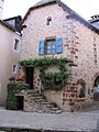 House in La Canourgue
 -
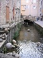 Canal in La Canourgue


วอกิชอ (รัฐวิสคอนซิน)
วอกิชอ รัฐวิสคอนซิน | |
|---|---|
Cเมืองและที่จั้งเทศมณฑล | |
| เมืองวอกิชอ | |
 ศาลเทศมณฑลวอกิชอเก่าใน ค.ศ. 2012 | |
 ที่ตั้งของวอกิชอในเทศมณฑลวอกิชอ รัฐวิสคอนซิน | |
| พิกัด: 43°00′42″N 88°13′54″W / 43.01167°N 88.23167°W{{#coordinates:}}: ไม่สามารถมีป้ายกำกับหลักมากกว่าหนึ่งป้ายต่อหน้าได้ | |
| ประเทศ | สหรัฐ |
| รัฐ | วิสคอนซิน |
| เทศมณฑล | วอกิชอ |
| การปกครอง | |
| • นายก | ชอว์น เอ็น. เรล์ลี |
| พื้นที่[1] | |
| • Cเมืองและที่จั้งเทศมณฑล | 25.80 ตร.ไมล์ (66.83 ตร.กม.) |
| • พื้นดิน | 25.53 ตร.ไมล์ (66.12 ตร.กม.) |
| • พื้นน้ำ | 0.27 ตร.ไมล์ (0.70 ตร.กม.) 1.04% |
| ประชากร | |
| • Cเมืองและที่จั้งเทศมณฑล | 70,718 คน |
| • ประมาณ (2019)[3] | 72,299 คน |
| • ความหนาแน่น | 2,831.92 คน/ตร.ไมล์ (1,093.39 คน/ตร.กม.) |
| • รวมปริมณฑล | 1,760,268 คน |
| The population figure given for the metropolitan area is for the Milwaukee metropolitan area, which includes Waukesha | |
| เขตเวลา | UTC−6 (กลาง) |
| • ฤดูร้อน (เวลาออมแสง) | UTC−5 (Central) |
| ZIP Codes | 53186-53189 |
| รหัสพื้นที่ | 262 |
| FIPS code | 55-84250 |
| เว็บไซต์ | waukesha-wi |
วอกิชอ (อังกฤษ: Waukesha, /ˈwɔːkɪʃɔː/) เป็นเมืองและที่ตั้งเทศมณฑลในWaukesha County, Wisconsin, United States. It is part of the Milwaukee metropolitan area. Its population was 70,718 at the 2010 census. The city is adjacent to the Village of Waukesha.
ชื่อวอกิชอ
"Waukesha" is thought to be an Anglicization of the Ojibwe word Waagoshag, the plural of fox ("waagosh"), or the Potawatomi name Wau-tsha. Wau-tsha (sometimes written as Wauk-tsha[4] or Wauke-tsha) was the leader of the local tribe at the time of the first European settlement of the area. This is confirmed by accounts of Increase A. Lapham, an early settler and historian of the region.[5] According to Lapham, the Algonquian word for "fox" was pishtaka.[6] Cutler also told visitors about Wau-tsha, who was described as "tall and athletic, proud in his bearing, dignified and friendly."[4]
พื้นที่และภูมิอากาศ
According to the United States Census Bureau, the city has a total area of 25.07 ตารางไมล์ (64.93 ตารางกิโลเมตร), of which 24.81 ตารางไมล์ (64.26 ตารางกิโลเมตร) is land and 0.26 ตารางไมล์ (0.67 ตารางกิโลเมตร) is water.[7]
The Köppen-Geiger climate classification system classifies its climate as humid continental (Dfa).
| ข้อมูลภูมิอากาศของWaukesha WWTP, Wisconsin (1991–2020 normals, extremes 1894–present) | |||||||||||||
|---|---|---|---|---|---|---|---|---|---|---|---|---|---|
| เดือน | ม.ค. | ก.พ. | มี.ค. | เม.ย. | พ.ค. | มิ.ย. | ก.ค. | ส.ค. | ก.ย. | ต.ค. | พ.ย. | ธ.ค. | ทั้งปี |
| อุณหภูมิสูงสุดที่เคยบันทึก °F (°C) | 62 (16.7) |
66 (18.9) |
82 (27.8) |
91 (32.8) |
101 (38.3) |
101 (38.3) |
109 (42.8) |
102 (38.9) |
101 (38.3) |
88 (31.1) |
78 (25.6) |
68 (20) |
109 (42.8) |
| อุณหภูมิสูงสุดเฉลี่ย °F (°C) | 27.7 (-2.39) |
31.5 (-0.28) |
43.0 (6.11) |
55.3 (12.94) |
67.3 (19.61) |
77.4 (25.22) |
81.4 (27.44) |
79.8 (26.56) |
72.9 (22.72) |
60.0 (15.56) |
45.0 (7.22) |
33.0 (0.56) |
56.2 (13.44) |
| อุณหภูมิเฉลี่ยแต่ละวัน °F (°C) | 19.7 (-6.83) |
23.0 (-5) |
33.5 (0.83) |
45.1 (7.28) |
56.6 (13.67) |
66.5 (19.17) |
70.9 (21.61) |
69.4 (20.78) |
62.0 (16.67) |
49.9 (9.94) |
36.7 (2.61) |
25.5 (-3.61) |
46.6 (8.11) |
| อุณหภูมิต่ำสุดเฉลี่ย °F (°C) | 11.6 (-11.33) |
14.6 (-9.67) |
24.0 (-4.44) |
34.8 (1.56) |
45.8 (7.67) |
55.6 (13.11) |
60.3 (15.72) |
58.9 (14.94) |
51.1 (10.61) |
39.8 (4.33) |
28.3 (-2.06) |
18.1 (-7.72) |
36.9 (2.72) |
| อุณหภูมิต่ำสุดที่เคยบันทึก °F (°C) | −27 (-32.8) |
−28 (-33.3) |
−14 (-25.6) |
7 (-13.9) |
25 (-3.9) |
29 (-1.7) |
41 (5) |
35 (1.7) |
25 (-3.9) |
7 (-13.9) |
−9 (-22.8) |
−28 (-33.3) |
−28 (−33.3) |
| หยาดน้ำฟ้า นิ้ว (มม) | 1.60 (40.6) |
1.71 (43.4) |
1.93 (49) |
3.65 (92.7) |
3.97 (100.8) |
4.88 (124) |
3.99 (101.3) |
4.18 (106.2) |
3.27 (83.1) |
2.92 (74.2) |
2.15 (54.6) |
1.70 (43.2) |
35.95 (913.1) |
| ปริมาณหิมะ นิ้ว (ซม) | 10.4 (26.4) |
10.1 (25.7) |
4.6 (11.7) |
1.1 (2.8) |
0.0 (0) |
0.0 (0) |
0.0 (0) |
0.0 (0) |
0.0 (0) |
0.1 (0.3) |
1.8 (4.6) |
8.8 (22.4) |
36.9 (93.7) |
| วันที่มีหยาดน้ำฟ้าโดยเฉลี่ย (≥ 0.01 in) | 9.4 | 8.2 | 7.6 | 11.0 | 12.8 | 11.2 | 8.9 | 9.2 | 8.6 | 9.8 | 8.5 | 9.4 | 114.6 |
| วันที่มีหิมะตกโดยเฉลี่ย (≥ 0.1 in) | 6.8 | 6.0 | 3.2 | 0.9 | 0.0 | 0.0 | 0.0 | 0.0 | 0.0 | 0.1 | 1.3 | 5.4 | 23.7 |
| แหล่งที่มา: NOAA[8][9] | |||||||||||||
Demographics
| ประชากร | |||
|---|---|---|---|
| สำมะโนประชากร | Pop. | %± | |
| 1860 | 1,456 | ||
| 1870 | 2,633 | 80.8% | |
| 1880 | 2,969 | 12.8% | |
| 1890 | 6,321 | 112.9% | |
| 1900 | 7,419 | 17.4% | |
| 1910 | 8,740 | 17.8% | |
| 1920 | 12,558 | 43.7% | |
| 1930 | 17,176 | 36.8% | |
| 1940 | 19,242 | 12.0% | |
| 1950 | 21,233 | 10.3% | |
| 1960 | 30,004 | 41.3% | |
| 1970 | 40,271 | 34.2% | |
| 1980 | 50,365 | 25.1% | |
| 1990 | 56,894 | 13.0% | |
| 2000 | 64,825 | 13.9% | |
| 2010 | 70,718 | 9.1% | |
| Est. 2019 | 72,299 | [3] | 2.2% |
| Source: U.S. Census[10] | |||
2010 census
As of the census[2] of 2010, there were 70,718 people, 28,295 households, and 17,506 families residing in the city. The population density was 2,850.4 คนต่อตารางไมล์ (1,100.5 คนต่อตารางกิโลเมตร). There were 29,843 housing units at an average density of 1,202.9 ต่อตารางไมล์ (464.4 ต่อตารางกิโลเมตร). The racial makeup of the city was 88.1% White, 2.3% African American, 0.4% Native American, 3.5% Asian, 3.5% from other races, and 2.1% from two or more races. Hispanic or Latino of any race were 12.1% of the population.
2000 census
As of the census[11] of 2000, there were 64,825 people, 25,663 households, and 16,296 families residing in the city. The population density was 3,000.5 people per square mile (1,158.8/km2). There were 26,856 housing units at an average density of 1,243.1 per square mile (480.1/km2). The racial makeup of the city was 91.22% White, 1.28% African American, 0.33% Native American, 2.17% Asian, 0.04% Pacific Islander, 3.31% from other races, and 1.65% from two or more races. Hispanic or Latino of any race were 8.58% of the population.
References
- ↑ "2019 U.S. Gazetteer Files". United States Census Bureau. สืบค้นเมื่อ 7 สิงหาคม 2020.
- ↑ 2.0 2.1 "U.S. Census website". United States Census Bureau. สืบค้นเมื่อ 18 พฤศจิกายน 2012.
- ↑ 3.0 3.1 "Population and Housing Unit Estimates". United States Census Bureau. 24 พฤษภาคม 2020. สืบค้นเมื่อ 27 พฤษภาคม 2020.
- ↑ 4.0 4.1 Wisconsin Archeological Society, The Wisconsin Archeologist, 1922, p. 71.
- ↑ Langill, Ellen D. & Jean Penn Loerke, From Farmlands to Freeways: A History of Waukesha County Wisconsin, Waukesha County Historical Society, 1984.
- ↑ A geographical and topographical description of Wisconsin..., p. 136.
- ↑ "US Gazetteer files 2010". United States Census Bureau. คลังข้อมูลเก่าเก็บจากแหล่งเดิมเมื่อ 12 มกราคม 2012. สืบค้นเมื่อ 18 พฤศจิกายน 2012.
- ↑ "NowData - NOAA Online Weather Data". National Oceanic and Atmospheric Administration. สืบค้นเมื่อ 15 มิถุนายน 2021.
- ↑ "Station: Waukesha WWTP, WI". U.S. Climate Normals 2020: U.S. Monthly Climate Normals (1991-2020). National Oceanic and Atmospheric Administration. สืบค้นเมื่อ 15 มิถุนายน 2021.
- ↑ Southeastern Wisconsin Regional Planning Commission (กรกฎาคม 2004). "The Population of Southeastern Wisconsin" (PDF). Technical Report Number 11 (4th Edition). คลังข้อมูลเก่าเก็บจากแหล่งเดิม (PDF)เมื่อ 31 ตุลาคม 2008. สืบค้นเมื่อ 9 เมษายน 2007.
{{cite journal}}: Cite journal ต้องการ|journal=(help) - ↑ "U.S. Census website". United States Census Bureau. สืบค้นเมื่อ 31 มกราคม 2008.
External links
- Official website
- Waukesha County Chamber of Commerce
- Sanborn fire insurance maps: 1884 1890 1895 1901 1911 1917 1922
Wat Phrik
ตำบล | |
|---|---|
| การถอดเสียงอักษรโรมัน | |
| • อักษรโรมัน | Tambon |
| พิกัด: Coordinates: Unable to parse latitude as a number:latitude {{#coordinates:}}: ละติจูดไม่ถูกต้อง | |
| ประเทศ | ไทย |
| จังหวัด | [[จังหวัด|]] |
| อำเภอ | [[อำเภอ|]] |
Wat Phrik วัดพริก (อังกฤษ: Chili Pepper Temple) | |
|---|---|
Subdistrict | |
| พิกัด: 16°45′00″N 100°14′00″E / 16.75000°N 100.23333°E{{#coordinates:}}: ไม่สามารถมีป้ายกำกับหลักมากกว่าหนึ่งป้ายต่อหน้าได้ | |
| Country | Thailand |
| Province | Phitsanulok |
| District | Mueang Phitsanulok District |
| ความสูง | 43 เมตร (141 ฟุต) |
| ประชากร (2005) | |
| • ทั้งหมด | 7,671 คน |
| เขตเวลา | UTC+7 (ICT) |
| Postal code | 65000 |
| Geocode | 650104 |
| Chief watercourse | Nan River |
Wat Phrik (ไทย: วัดพริก) is a subdistrict in the Mueang Phitsanulok District of Phitsanulok Province, Thailand.
Geography
The topography of Wat Phrik is flat lowlands. The subdistrict is bordered to the north by Tha Pho, to the east by Bueng Phra to the south by Wang Nam Khu and Ngio Ngam, and to the west by Wang Ithok of Bang Rakam District.[1] Wat Phrik lies in the Nan Basin, which is part of the Chao Phraya Watershed. The Nan River flows through the center of the subdistrict.[1]
History
Wan Phrik was originally part of tambon Bueng Phra.[1] The subdistrict has a history of chili pepper farming, from whence it derives its name.[1] Docks along the banks of the Nan River in Wat Phrik have been used throughout history for transporting agricultural products to other regions.
Administration
The following is a list of the subdistrict's muban (villages):[2]
| No. | English | Thai |
| 1 | Ban Mai | บ้านใหม่ |
| 2 | Ban Tha Rong (East) | บ้านท่าโรง (ตะวันออก) |
| 3 | Ban Yang Thon (East) | บ้านยางโทน (ตะวันออก) |
| 4 | Ban Wat Phrik | บ้านวัดพริก |
| 5 | Ban Wang Sam Sa | บ้านวังส้มซ่า คุ้งวัง |
| 6 | Ban Wat Lom | บ้านวัดหล่ม |
| 7 | Ban Wat Phrik (Sao Hin) | บ้านวัดพริก (เสาหิน) |
| 8 | Ban Yang Thon (East) | บ้านยางโทน (ตะวันออก) |
| 9 | Ban Tha Rong (West) | บ้านท่าโรง (ตะวันตก) |
| 10 | Ban Tha Rong | บ้านท่าโรง |
| 11 | Ban Mai Thawan Thok | บ้านใหม่ตะวันตก |
| 12 | Ban Lam Khai | บ้านลำได |
References
- ↑ 1.0 1.1 1.2 1.3 ThaiTambon.comแม่แบบ:Nonspecific
- ↑ Pitlocal.org (in Thai)[ลิงก์เสีย]
Sop Poeng
ตำบล | |
|---|---|
| การถอดเสียงอักษรโรมัน | |
| • อักษรโรมัน | Tambon |
| พิกัด: Coordinates: Unable to parse latitude as a number:latitude {{#coordinates:}}: ละติจูดไม่ถูกต้อง | |
| ประเทศ | ไทย |
| จังหวัด | [[จังหวัด|]] |
| อำเภอ | [[อำเภอ|]] |
Sop Poeng สบเปิง | |
|---|---|
| Country | Thailand |
| Province | Chiang Mai |
| Amphoe | Mae Taeng |
| ประชากร (2005) | |
| • ทั้งหมด | 7,977 คน |
| เขตเวลา | UTC+7 (ICT) |
Sop Poeng (ไทย: สบเปิง) is a tambon (sub-district) of Mae Taeng District, in Chiang Mai Province, Thailand.[1] In 2005 it had a population of 7,977 people. The tambon contains 13 villages.
| No. | Name | Thai name | |
|---|---|---|---|
| 1. | Ban Pang Hang | บ้านปางฮ่าง | |
| 2. | Ban Pang Muang | บ้านปางม่วง | |
| 3. | Ban Sop Poeng | บ้านสบเปิง | |
| 4. | Ban Ton Ngun | บ้านต้นงุ้น | |
| 5. | Ban Rai | บ้านไร่ | |
| 6. | Ban Tha Kham | บ้านท่าข้าม | |
| 7. | Ban Ton Lan | บ้านต้นลาน | |
| 8. | Ban Don Chiang | บ้านดอนเจียง | |
| 9. | Ban Nong Bua Luang | บ้านหนองบัวหลวง | |
| 10. | Ban Mae Lot | บ้านแม่หลอด | |
| 11. | Ban Pha Mon | บ้านผาหมอน | |
| 12. | Ban Long | บ้านล้อง | |
| 13. | Ban Sahakon Thung Mai | บ้านสหกรณ์ทุ่งใหม่ |
External links
References
- ↑ Thaitambon.com, Accessed April 25, 2010 [ไม่อยู่ในแหล่งอ้างอิง]
- ↑ code.google.com/p/tambon/, Accessed November 3, 2012 (ในภาษาไทย)
19°05′47″N 98°50′54″E / 19.0964°N 98.8483°E{{#coordinates:}}: ไม่สามารถมีป้ายกำกับหลักมากกว่าหนึ่งป้ายต่อหน้าได้
โนเนม (รัฐโคโลราโด)
โนเนม รัฐโคโลราโด | |
|---|---|
 ป้ายทางออก 119 ของอินเตอร์สเตต 70 | |
 ที่ตั้งของโนเนมในเทศมณฑลการ์ฟีลด์ รัฐโคโลราโด | |
 โนเนม ที่ตั้งของโนเนมในประเทศสหรัฐ | |
| พิกัด: 39°33′35″N 107°17′34″W / 39.5597304°N 107.2927865°W{{#coordinates:}}: ไม่สามารถมีป้ายกำกับหลักมากกว่าหนึ่งป้ายต่อหน้าได้[1] | |
| ประเทศ | |
| รัฐ | |
| เทศมณฑล | การ์ฟีลด์ |
| การปกครอง[2] | |
| • ประเภท | unincorporated community |
| พื้นที่[1] | |
| • ทั้งหมด | 0.179 ตร.ไมล์ (0.463 ตร.กม.) |
| • พื้นดิน | 0.179 ตร.ไมล์ (0.463 ตร.กม.) |
| • พื้นน้ำ | 0.000 ตร.ไมล์ (0.000 ตร.กม.) |
| ความสูง[2] | 5,869 ฟุต (1,789 เมตร) |
| ประชากร (2010) | |
| • ทั้งหมด | 123 คน |
| • ความหนาแน่น | 687 คน/ตร.ไมล์ (266 คน/ตร.กม.) |
| เขตเวลา | UTC-7 (เวลามาตรฐานภูเขา) |
| • ฤดูร้อน (เวลาออมแสง) | UTC-6 (เวลาออมแสงภูเขา) |
| รหัส ZIP[3] | Glenwood Springs 81601 |
| รหัสพื้นที่ | 970 |
| GNIS feature[2] | No Name CDP |
โนเนม (อังกฤษ: No Name) เป็นunincorporated community and a census-designated place (CDP) located in and governed by Garfield County, Colorado, United States. The CDP is a part of the Glenwood Springs, CO Micropolitan Statistical Area. The population of the No Name CDP was 123 at the United States Census 2010.[4] The Glenwood Springs post office (Zip Code 81601) serves the area.[3]
ภูมิศาสตร์
No Name is located east of Glenwood Springs, off Exit 119 of Interstate 70 in Glenwood Canyon. It is named for No Name Creek and No Name Canyon. The No Name Tunnel of I-70 is nearby. It has frequently been noted on lists of unusual place names.[5]
The No Name CDP has an area of 114 เอเคอร์ (0.463 ตารางกิโลเมตร), all land.[1]
References
- ↑ 1.0 1.1 1.2 "State of Colorado Census Designated Places - BAS20 - Data as of January 1, 2020". United States Census Bureau. สืบค้นเมื่อ 22 ธันวาคม 2020.
- ↑ 2.0 2.1 2.2 "U.S. Board on Geographic Names: Domestic Names". United States Geological Survey. สืบค้นเมื่อ 19 ธันวาคม 2020.
- ↑ 3.0 3.1 "Zip Code 81601 Map and Profile". zipdatamaps.com. 2020. สืบค้นเมื่อ 22 ธันวาคม 2020.
- ↑ "2010: DEC Summary File 1". United States Census Bureau. สืบค้นเมื่อ 22 ธันวาคม 2020.
- ↑ Parker, Quentin (18 กรกฎาคม 2010). Welcome to Horneytown, North Carolina, Population: 15: An insider's guide to 201 of the world's weirdest and wildest places. Adams Media. p. xi.
External links
 หาความหมายจากวิกิพจนานุกรม
 ภาพและสื่อจากคอมมอนส์
 เนื้อหาข่าวจากวิกิข่าว
 คำคมจากวิกิคำคม
 ข้อมูลต้นฉบับจากวิกิซอร์ซ
 หนังสือจากวิกิตำรา
Moorhead, Minnesota
Moorhead | |
|---|---|
 Moorhead City Hall | |
| สมญา: Your Hometown | |
 Location within Clay County | |
| ข้อผิดพลาด Lua ใน มอดูล:Location_map บรรทัดที่ 522: Unable to find the specified location map definition: "Module:Location map/data/Minnesota" does not exist | |
| พิกัด: 46°52′26″N 96°46′02″W / 46.87389°N 96.76722°W{{#coordinates:}}: ไม่สามารถมีป้ายกำกับหลักมากกว่าหนึ่งป้ายต่อหน้าได้ | |
| Country | United States |
| State | Minnesota |
| County | Clay |
| Founded | 1871 |
| การปกครอง | |
| • Mayor | Johnathan Judd |
| พื้นที่[1] | |
| • City | 22.27 ตร.ไมล์ (57.69 ตร.กม.) |
| • พื้นดิน | 22.27 ตร.ไมล์ (57.67 ตร.กม.) |
| • พื้นน้ำ | 0.01 ตร.ไมล์ (0.02 ตร.กม.) |
| ความสูง | 898 ฟุต (274 เมตร) |
| ประชากร | |
| • City | 38,065 คน |
| • ประมาณ (2019)[3] | 43,652 คน |
| • ความหนาแน่น | 1,960.39 คน/ตร.ไมล์ (756.89 คน/ตร.กม.) |
| • เขตเมือง | 176,676 (US: 194th) คน |
| • รวมปริมณฑล | 245,471 (US: 189th) คน |
| เขตเวลา | UTC−6 (CST) |
| • ฤดูร้อน (เวลาออมแสง) | UTC−5 (CDT) |
| ZIP codes | 56560–56563 |
| Area code | 218 |
| FIPS code | 27-43864 |
| GNIS feature ID | 0648070[4] |
| เว็บไซต์ | เว็บไซต์ทางการ |
Moorhead is a city in Clay County, Minnesota, United States, and the largest city in northwest Minnesota. The population was 38,065 according to the 2010 census. 2019 estimated population is 42,939.[5] It is the county seat of Clay County.[6]
Moorhead was platted in 1871. The city was named for William Galloway Moorhead, an official of the Northern Pacific Railway.[7] Moorhead is bordered on the west by the Red River of the North and the city of Fargo, North Dakota. On the east, Moorhead is bordered by Dilworth, Minnesota. Moorhead, along with its twin city of Fargo, North Dakota, as well as adjacent West Fargo, form the core of the Fargo–Moorhead metropolitan area, which has a 2010 population of around 208,777 residents.
Geography
Moorhead is located adjacent to the Red River in the Red River Valley. The land around the Fargo–Moorhead area is some of the flattest and richest (for agricultural uses) in the world. This is because it lies on the lake bed of glacial Lake Agassiz, which drained between 9,900 and 11,000 years ago.[8]
According to the U.S. Census Bureau, the city has a total area of 19.80 ตารางไมล์ (51.28 ตารางกิโลเมตร), all land.[9]
Interstate 94 and U.S. Highways 10, 52 and 75 (conjoined with I-94) are four of the main routes in the city. Other nearby routes in the Fargo–Moorhead area include Interstate 29 and Minnesota State Highway 336.
Demographics
| ประชากร | |||
|---|---|---|---|
| สำมะโนประชากร | Pop. | %± | |
| 1880 | 1,500 | ||
| 1890 | 2,088 | 39.2% | |
| 1900 | 3,730 | 78.6% | |
| 1910 | 4,540 | 21.7% | |
| 1920 | 5,720 | 26.0% | |
| 1930 | 7,651 | 33.8% | |
| 1940 | 9,491 | 24.0% | |
| 1950 | 14,870 | 56.7% | |
| 1960 | 22,934 | 54.2% | |
| 1970 | 29,687 | 29.4% | |
| 1980 | 29,998 | 1.0% | |
| 1990 | 32,295 | 7.7% | |
| 2000 | 32,177 | −0.4% | |
| 2010 | 38,065 | 18.3% | |
| Est. 2019 | 43,652 | [3] | 14.7% |
| U.S. Decennial Census[10] 2018 Estimate[11] | |||
2010 census
As of the census[2] of 2010, there were 38,065 people, 14,304 households, and 8,372 families living in the city. The population density was 1,922.5 คนต่อตารางไมล์ (742.3 คนต่อตารางกิโลเมตร). There were 15,274 housing units at an average density of 771.4 ต่อตารางไมล์ (297.8 ต่อตารางกิโลเมตร). The racial makeup of the city was 90.7% White, 2.0% African American, 1.5% Native American, 2.0% Asian, 1.1% from other races, and 2.6% from two or more races. Hispanic or Latino of any race were 4.1% of the population.
2000 census
As of the census of 2000, there were 32,177 people, 11,660 households, and 7,030 families living in the city. The population density was 2,394.3 people per square mile (924.4/km2). There were 12,180 housing units at an average density of 906.3 per square mile (349.9/km2). The racial makeup of the city was 92.08% White, 0.77% African American, 1.94% Native American, 1.27% Asian, 0.04% Pacific Islander, 2.10% from other races, and 1.79% from two or more races. Hispanic or Latino of any race were 4.47% of the population.
References
- ↑ "2019 U.S. Gazetteer Files". United States Census Bureau. สืบค้นเมื่อ 26 กรกฎาคม 2020.
- ↑ 2.0 2.1 "U.S. Census website". United States Census Bureau. สืบค้นเมื่อ 13 พฤศจิกายน 2012.
- ↑ 3.0 3.1 "Population and Housing Unit Estimates". United States Census Bureau. 24 พฤษภาคม 2020. สืบค้นเมื่อ 27 พฤษภาคม 2020.
- ↑ "US Board on Geographic Names". United States Geological Survey. 25 ตุลาคม 2007. สืบค้นเมื่อ 31 มกราคม 2008.
- ↑ "2010 Census Redistricting Data (Public Law 94-171) Summary File". American FactFinder. U.S. Census Bureau, 2010 Census. สืบค้นเมื่อ 23 เมษายน 2011.[ลิงก์เสีย]
- ↑ "Find a County". National Association of Counties. สืบค้นเมื่อ 7 มิถุนายน 2011.
- ↑ Upham, Warren (1920). Minnesota Geographic Names: Their Origin and Historic Significance. Minnesota Historical Society. p. 117.
- ↑ [1] เก็บถาวร มิถุนายน 3, 2010 ที่ เวย์แบ็กแมชชีน
- ↑ "US Gazetteer files 2010". United States Census Bureau. คลังข้อมูลเก่าเก็บจากแหล่งเดิมเมื่อ 2 กรกฎาคม 2012. สืบค้นเมื่อ 13 พฤศจิกายน 2012.
- ↑ United States Census Bureau. "Census of Population and Housing". สืบค้นเมื่อ 11 กันยายน 2013.
- ↑ "Population Estimates". United States Census Bureau. สืบค้นเมื่อ 28 พฤษภาคม 2019.
External links
 คู่มือการท่องเที่ยว Moorhead จากวิกิท่องเที่ยว (ในภาษาอังกฤษ)
- ไม่พบ URL โปรดระบุ URL ที่นี่หรือเพิ่ม URL ในวิกิสนเทศ
Municipalities of Qatar
| Municipalities of Qatar بلديات قطر (อาหรับ) | |
|---|---|
 | |
| หมวดหมู่ | Unitary state |
| ที่ตั้ง | State of Qatar |
| จำนวน | 8 Municipalities |
| ประชากร | 8,794 (Al Shamal) – 956,457 (Doha) |
| พื้นที่ | 203 km2 (78.3 sq mi) (Doha) – 3,309 km2 (1,277.6 sq mi) (Al-Shahaniya) |
| การปกครอง | Municipality government, National government |
| หน่วยการปกครอง | Zones |
Since 2015, Qatar has been divided into eight municipalities.[1] A new municipality, Al Daayen, was created under Resolution No. 13,[2] formed from parts of Umm Salal and Al Khawr; at the same time, Al Ghuwariyah was merged with Al Khawr; Al Jumaliyah was merged with Ar Rayyan; Jarayan al Batnah was split between Ar Rayyan and Al Wakrah; and Mesaieed was merged with Al Wakrah.[3] In 2014, the western city of Al-Shahaniya split off from Al Rayyan Municipality to form its own municipality.[4]
For statistical purposes, the municipalities are further subdivided into 98 zones (as of 2015), which are in turn subdivided into districts and blocks, the latter being the lowest subdivision.[5]
History
According to Ministry of Municipality and Urban Planning,[6] in 1963, the first municipality was the Municipality of Qatar, created under Law No. 11. Later in the same year, its name was changed to Municipality of Doha by Law No. 15. Then, on 17 July 1972, Ar Rayyan, Al Wakrah, Al Khawr and Dhekra, Ash Shamal, and Umm Salal municipalities created under Resolution No.11. In 1997, Umm Sa'id municipality formed from parts of Al Wakrah (former HASC code QA.WA, FIPS code QA05) and Jariyan al Batnah (QA.JB, QA07).
In 2004, Al Daayen municipality created under Resolution No. 13. Judging from maps of the municipalities before and after this change, Al Daayen was formed from parts of Umm Salal and Al Khawr; at the same time, Al Ghuwariyah merged with Al Khawr; Al Jumaliyah merged with Ar Rayyan; and Jarayan al Batnah was split between Ar Rayyan and Al Wakrah.
In 2014, the western city of Al-Shahaniya was dissociated from Al Rayyan Municipality to form its own municipality. Integrating approximately 35% of Al Rayyan's area into the new municipality, some of Al Rayyan's western localities such as Al Gharbiam, Al Utouriya, Al Jemailiya, Umm Bab, Rawdat Rashed, Al Nasraniya, Dukhan and Al Khurayb were also included in the new municipality.[4]
Municipalities
| Key | Municipality (Baladiyah) |
بلدية | Population (2015)[5] |
Area (km2) |
Area (mi2) |
|---|---|---|---|---|---|
| 1 | Al Shamal | الشمال | 8,794 | 859.8 | 331.9 |
| 2 | Al Khor | الخور | 202,031 | 1,613.3 | 622.8 |
| 3 | Al-Shahaniya | الشحانية | 187,571 | 3,309.0 | 1,277.6 |
| 4 | Umm Salal | أم صلال | 90,835 | 318.4 | 122.9 |
| 5 | Al Daayen | الضعاين | 54,339 | 290.2 | 112.0 |
| 6 | Ad Dawhah (Doha) | الدوحة | 956,457 | 202.7 | 78.3 |
| 7 | Al Rayyan | الريان | 605,712 | 2,450 | 946.0 |
| 8 | Al Wakrah | الوكرة | 299,037 | 2,577.7 | 995.2 |
| Dawlat Qatar | دولة قطر | 2,404,776 | 11,621.1 | 4,486.7 |
Former municipalities
- Al Jemailiya (until 2004)[7]
- Al Ghuwariyah (until 2004)[7]
- Jariyan al Batnah (until 2004)[7]
- Mesaieed (Umm Sa'id) (until 2006)[8]
See also
References
- ↑ "Qatar Municipalities". Qatar Ministry of Municipality and Environment. สืบค้นเมื่อ 8 สิงหาคม 2017.
- ↑ AlDaayen Municipality
- ↑ "Qatar Census Geography & Administrative Boundary 1986-2015". Ministry of Development Planning and Statistics. สืบค้นเมื่อ 9 สิงหาคม 2017.
- ↑ 4.0 4.1 Hisham Yassin (16 มกราคม 2014). "بلدية الشحانية تضم %35 من مساحة الريان الحالية" (ภาษาอาหรับ). Al Arab. สืบค้นเมื่อ 8 สิงหาคม 2017.
- ↑ 5.0 5.1 "2015 Population census" (PDF). Ministry of Development Planning and Statistics. เมษายน 2015. สืบค้นเมื่อ 8 สิงหาคม 2017.
- ↑ "وزارة البلدية والبيئة". www.baladiya.gov.qa.
- ↑ 7.0 7.1 7.2 "Population By Gender, Municipality And Zone". Ministry of Development Planning and Statistics. มีนาคม 2004. สืบค้นเมื่อ 9 สิงหาคม 2017.
- ↑ "Law No. 12 of 2006 concerning the Cancelled Municipality of Mesaieed". almeezan.qa. สืบค้นเมื่อ 9 สิงหาคม 2017.
แม่แบบ:Municipalities of Qatar แม่แบบ:Articles on first-level administrative divisions of Asian countries แม่แบบ:Qatar topics
Milledgeville, Georgia
แม่แบบ:Use American English แม่แบบ:Use mdy dates
Milledgeville, Georgia | |
|---|---|
| City of Milledgeville | |
 | |
| คำขวัญ: "Capitols, Columns and Culture" | |
 Location in Baldwin County and the state of Georgia | |
 Milledgeville Location of Milledgeville in the US | |
| พิกัด: 33°5′16″N 83°14′0″W / 33.08778°N 83.23333°W{{#coordinates:}}: ไม่สามารถมีป้ายกำกับหลักมากกว่าหนึ่งป้ายต่อหน้าได้ | |
| Country | |
| State | |
| County | Baldwin |
| Incorporated | 12 ธันวาคม 1804 |
| ตั้งชื่อจาก | John Milledge |
| การปกครอง[1] | |
| • ประเภท | Council–Manager |
| • Mayor | Mary Parham-Copelan |
| • Manager | Barry Jarrett |
| • Council | Members
|
| พื้นที่[2] | |
| • ทั้งหมด | 20.50 ตร.ไมล์ (53.10 ตร.กม.) |
| • พื้นดิน | 20.34 ตร.ไมล์ (52.68 ตร.กม.) |
| • พื้นน้ำ | 0.16 ตร.ไมล์ (0.42 ตร.กม.) |
| ความสูง | 330 ฟุต (100 เมตร) |
| ประชากร (2010) | |
| • ทั้งหมด | 17,715 คน |
| • ประมาณ (2019)[3] | 18,704 คน |
| • ความหนาแน่น | 919.52 คน/ตร.ไมล์ (355.04 คน/ตร.กม.) |
| เขตเวลา | UTC-5 (Eastern Time) |
| • ฤดูร้อน (เวลาออมแสง) | UTC-4 (EDT) |
| ZIP code(s) | 31061 |
| Area code(s) | 478 |
| FIPS code | 13-51492[4] |
| GNIS feature ID | 0332390[5] |
| เว็บไซต์ | milledgevillega |
Milledgeville is a city in and the county seat of Baldwin County[6] in the U.S. state of Georgia. It is northeast of Macon and bordered on the east by the Oconee River. The rapid current of the river here made this an attractive location to build a city. It was the capital of Georgia from 1804 to 1868, including during the American Civil War. Milledgeville was preceded as the capital city by Louisville and was succeeded by Atlanta, the current capital. Today U.S. Highway 441 connects Milledgeville to Madison, Athens, and Dublin.
As of July 1, 2019, the population of Milledgeville was 18,704, up from 17,715 at the 2010 US Census.[7]
Milledgeville is along the route of the Fall Line Freeway, which is under construction to link Milledgeville with Augusta, Macon, Columbus, and other Fall Line cities. They have long histories from the colonial era of Georgia.
Milledgeville is the principal city of the Milledgeville Micropolitan Statistical Area, a micropolitan area that includes Baldwin and Hancock counties.[8] It had a combined population of 54,776 at the 2000 census.[4] The Old State Capitol is located here; it was added to the National Register of Historic Places (NRHP). Much of the original city is contained within the boundaries of the Milledgeville Historic District, which was also added to the NRHP.
Geography
Milledgeville is located at 33°5′16″N 83°14′0″W / 33.08778°N 83.23333°W (33.087755, -83.233401)[9] and is 301 ฟุต (92 เมตร) above sea level.
According to the United States Census Bureau, the city has a total area of 20.6 ตารางไมล์ (53.3 ตารางกิโลเมตร), of which 20.4 ตารางไมล์ (52.9 ตารางกิโลเมตร) is land and 0.15 ตารางไมล์ (0.4 ตารางกิโลเมตร), or 0.74%, is water.[10]
U.S. Route 441 is the main route through the city, leading north 21 mi (34 km) to Eatonton and south 22 mi (35 km) to Irwinton. Georgia State Routes 22, 24, and 49 also run through the city as well. GA-22 leads northeast 24 mi (39 km) to Sparta and southwest 20 mi (32 km) to Gray. GA-24 leads east 29 mi (47 km) to Sandersville and north to Eatonton with U.S. 441. GA-49 leads southwest 30 mi (48 km) to Macon.
Milledgeville is located on the Atlantic Seaboard fall line of the United States. The Oconee River flows a half mile east of downtown on its way south to the Altamaha River and then south to the Atlantic Ocean. Lake Sinclair, a man-made lake, is about 5 ไมล์ (8 กิโลเมตร) northeast of Milledgeville on the border of Baldwin, Putnam and Hancock counties.
Milledgeville is composed of two main districts: a heavily commercialized area along the highway known to locals simply as "441," extending from a few blocks north of Georgia College & State University to 4 ไมล์ (6 กิโลเมตร) north of Milledgeville, and the "Downtown" area, encompassing the college, buildings housing city government agencies, various bars and restaurants. This historic area was laid out in 1803, with streets named after other counties in Georgia.
Demographics
| ประชากร | |||
|---|---|---|---|
| สำมะโนประชากร | Pop. | %± | |
| 1810 | 1,256 | ||
| 1820 | 2,069 | 64.7% | |
| 1840 | 2,095 | ||
| 1850 | 2,216 | 5.8% | |
| 1860 | 2,480 | 11.9% | |
| 1870 | 2,750 | 10.9% | |
| 1880 | 3,800 | 38.2% | |
| 1890 | 3,322 | −12.6% | |
| 1900 | 4,219 | 27.0% | |
| 1910 | 4,385 | 3.9% | |
| 1920 | 4,619 | 5.3% | |
| 1930 | 5,534 | 19.8% | |
| 1940 | 6,778 | 22.5% | |
| 1950 | 8,835 | 30.3% | |
| 1960 | 11,117 | 25.8% | |
| 1970 | 11,601 | 4.4% | |
| 1980 | 12,176 | 5.0% | |
| 1990 | 17,727 | 45.6% | |
| 2000 | 18,757 | 5.8% | |
| 2010 | 17,715 | −5.6% | |
| Est. 2019 | 18,704 | [3] | 5.6% |
| U.S. Decennial Census[11] | |||
The population of the town of Milledgeville was 17,715 at the 2010 census.[10]
As of the census[4] of 2000, there were 18,757 people, 4,755 households, and 2,643 families residing in the city, although a 2005 study estimates there to be a population of 19,397. The population density was 938.8 people per square mile (362.5/km2). There were 5,356 housing units at an average density of 268.1 per square mile (103.5/km2). The racial makeup of the city was 49.94% White, 47.68% African American, 0.13% Native American, 1.55% Asian, 0.01% Pacific Islander, 0.20% from other races, and 0.50% from two or more races. Hispanic or Latino people of any race were 1.23% of the population.
There were 4,755 households, out of which 25.9% had children under the age of 18 living with them, 33.6% were married couples living together, 18.7% had a female householder with no husband present, and 44.4% were non-families. 31.7% of all households were made up of individuals, and 10.7% had someone living alone who was 65 years of age or older. The average household size was 2.35 and the average family size was 3.04.
In the city, the population was spread out, with 16.0% under the age of 18, 20.9% from 18 to 24, 32.3% from 25 to 44, 19.6% from 45 to 64, and 11.2% who were 65 years of age or older. The median age was 33 years. For every 100 females, there were 166.0 males. For every 100 females age 18 and over, there were 173.2 males.
The median income for a household in the city was $30,484, and the median income for a family was $44,683. Males had a median income of $30,794 versus $23,719 for females. The per capita income for the city was $12,782. About 14.8% of families and 24.0% of the population were below the poverty line, including 28.8% of those under age 18 and 16.3% of those age 65 or over.
References
- ↑ "Milledgeville City Hall". 2017. เก็บจากแหล่งเดิมเมื่อ 4 พฤษภาคม 2017. สืบค้นเมื่อ 16 พฤษภาคม 2017.
- ↑ "2019 U.S. Gazetteer Files". United States Census Bureau. สืบค้นเมื่อ 9 กรกฎาคม 2020.
- ↑ 3.0 3.1 "Population and Housing Unit Estimates". United States Census Bureau. 24 พฤษภาคม 2020. สืบค้นเมื่อ 27 พฤษภาคม 2020.
- ↑ 4.0 4.1 4.2 "U.S. Census website". United States Census Bureau. สืบค้นเมื่อ 31 มกราคม 2008.
- ↑ "US Board on Geographic Names". United States Geological Survey. 25 ตุลาคม 2007. เก็บจากแหล่งเดิมเมื่อ 12 กุมภาพันธ์ 2012. สืบค้นเมื่อ 31 มกราคม 2008.
- ↑ "Find a County". National Association of Counties. เก็บจากแหล่งเดิมเมื่อ 31 พฤษภาคม 2011. สืบค้นเมื่อ 7 มิถุนายน 2011.
- ↑ "QuickFacts Milledgeville city, Georgia". United States Census Bureau. n.d. เก็บจากแหล่งเดิมเมื่อ 26 มิถุนายน 2019. สืบค้นเมื่อ 27 มิถุนายน 2019.
- ↑ MICROPOLITAN STATISTICAL AREAS AND COMPONENTS, Office of Management and Budget, 2007-05-11. Accessed 2008-07-27.
- ↑ "US Gazetteer files: 2010, 2000, and 1990". United States Census Bureau. 12 กุมภาพันธ์ 2011. สืบค้นเมื่อ 23 เมษายน 2011.
- ↑ 10.0 10.1 "Geographic Identifiers: 2010 Demographic Profile Data (G001): Milledgeville city, Georgia (Revision published Jan. 25, 2013)". U.S. Census Bureau, American Factfinder. คลังข้อมูลเก่าเก็บจากแหล่งเดิมเมื่อ 12 กุมภาพันธ์ 2020. สืบค้นเมื่อ 28 ตุลาคม 2013.
- ↑ "Census of Population and Housing". Census.gov. สืบค้นเมื่อ 4 มิถุนายน 2015.
Further reading
- Strong, Robert Hale (1961). Halsey, Ashley (บ.ก.). A Yankee Private's Civil War. Chicago: Henry Regnery Company. pp. 67–70. LCCN 61-10744. OCLC 1058411.
External links
- ภาพและสื่อจากคอมมอนส์
 ข้อมูลการเดินทางจากวิกิท่องเที่ยว
 ข้อมูลจากวิกิสนเทศ
- Government
- General information
 ดูข้อมูลทางภูมิศาสตร์ที่เกี่ยวข้องกับ Waniosa Amedestir/ทดลองเขียน 2 ที่โอเพินสตรีตแมป
- Milledgeville, Georgia at City-Data.com
- Milledgeville, Georgia at New Georgia Encyclopedia
- Milledgeville – Baldwin County Convention & Visitors Bureau
- Milledgeville Historic Newspapers Archive at Digital Library of Georgia
แม่แบบ:Baldwin County, Georgia
คำเตือน: หลักเรียงลำดับปริยาย "Milledgeville, Georgia" ได้ลบล้างหลักเรียงลำดับปริยาย "Saint-Sauveur-De-Ginestoux" ที่มีอยู่ก่อนหน้า
London, Ontario
London | |
|---|---|
City (single-tier) | |
| City of London | |
 Clockwise from top: London skyline as of 2009, Victoria Park, London Normal School, Financial District, Budweiser Gardens | |
|
ตราราชการของLondon ตราอาร์ม | |
| สมญา: "The Forest City" | |
| คำขวัญ: | |
| ข้อผิดพลาด Lua ใน มอดูล:Location_map บรรทัดที่ 522: Unable to find the specified location map definition: "Module:Location map/data/CAN ON Middlesex" does not exist | |
| พิกัด: 42°58′03″N 081°13′57″W / 42.96750°N 81.23250°W{{#coordinates:}}: ไม่สามารถมีป้ายกำกับหลักมากกว่าหนึ่งป้ายต่อหน้าได้ | |
| Country | Canada |
| Province | Ontario |
| Settled | 1826 (as village) |
| Incorporated | 1855 (as city) |
| ตั้งชื่อจาก | London, United Kingdom |
| การปกครอง | |
| • City Mayor | Ed Holder |
| • Governing Body | London City Council |
| • MPs | List of MPs |
| • MPPs | List of MPPs |
| พื้นที่[1][2] | |
| • พื้นดิน | 420.57 ตร.กม. (162.38 ตร.ไมล์) |
| • เขตเมือง | 232.48 ตร.กม. (89.76 ตร.ไมล์) |
| • รวมปริมณฑล | 2,662.40 ตร.กม. (1,027.96 ตร.ไมล์) |
| ความสูง | 251 เมตร (823 ฟุต) |
| ประชากร (2016)[3] | |
| • City (single-tier) | 383,822 (15th) คน |
| • ความหนาแน่น | 913.1 คน/ตร.กม. (2,365 คน/ตร.ไมล์) |
| • รวมปริมณฑล | 494,069 (11th) คน |
| เขตเวลา | UTC−05:00 (EST) |
| • ฤดูร้อน (เวลาออมแสง) | UTC−04:00 (EDT) |
| Forward sortation area | N5V to N6P |
| รหัสพื้นที่ | 519, 226, and 548 |
| GDP (London CMA) | CA$24.0 billion (2016)[4] |
| GDP per capita (London CMA) | CA$48,530 (2016) |
| เว็บไซต์ | www.london.ca |

London (pronounced /ˈlʌndən/) is a city in southwestern Ontario, Canada, along the Quebec City–Windsor Corridor. The city had a population of 383,822 according to the 2016 Canadian census. London is at the confluence of the Thames River, approximately 200 km (120 mi) from both Toronto and Detroit; and about 230 km (140 mi) from Buffalo, New York. The city of London is a separated municipality, politically separate from Middlesex County, though it remains the county seat.
London and the Thames were named in 1793 by John Graves Simcoe, who proposed the site for the capital city of Upper Canada. The first European settlement was between 1801 and 1804 by Peter Hagerman.[5] The village was founded in 1826 and incorporated in 1855. Since then, London has grown to be the largest southwestern Ontario municipality and Canada's 11th largest metropolitan area, having annexed many of the smaller communities that surrounded it.
London is a regional centre of healthcare and education, being home to the University of Western Ontario (which brands itself "Western University"), Fanshawe College, and several hospitals (including a University Hospital). The city hosts a number of musical and artistic exhibits and festivals, which contribute to its tourism industry, but its economic activity is centred on education, medical research, insurance, and information technology. London's university and hospitals are among its top ten employers. London lies at the junction of Highway 401 and 402, connecting it to Toronto, Windsor and Sarnia. It also has an international airport and train and bus stations.
Etymology
London was named for the British capital of London by John Graves Simcoe, who also named the local river the Thames, in 1793.[6] Simcoe had intended London to be the capital of Upper Canada. Guy Carleton (Governor Dorchester) rejected that plan after the War of 1812,[7] but accepted Simcoe's second choice, the present site of Toronto, to become the capital city of what would become the Province of Ontario, at Confederation, on 1 July 1867.[8]
Geography
The area was formed during the retreat of the glaciers during the last ice age, which produced areas of marshland, notably the Sifton Bog, as well as some of the most agriculturally productive areas of farmland in Ontario.[9] The Thames River dominates London's geography. The North and South branches of the Thames River meet at the centre of the city, a location known as "The Forks" or "The Fork of the Thames."[10] The North Thames runs through the man-made Fanshawe Lake in northeast London. Fanshawe Lake was created by Fanshawe Dam, constructed to protect the downriver areas from the catastrophic flooding which affected the city in 1883 and 1937.[11]
Climate

London has a humid continental climate (Köppen Dfb), though due to its downwind location relative to Lake Huron and elevation changes across the city, it is virtually on the Dfa/Dfb (hot summer) boundary favouring the former climate zone to the southwest of the confluence of the South and North Thames Rivers, and the latter zone to the northeast (including the airport). Because of its location in the continent, London experiences large seasonal contrast, tempered to a point by the surrounding Great Lakes. The summers are usually warm to hot and humid, with a July average of 20.8 องศาเซลเซียส (69.4 องศาฟาเรนไฮต์), and temperatures above 30 °C (86 °F) occur on average 10 days per year.[12] In 2016, however, temperatures at or above 30 °C (86 °F) occurred more than 35 times, and in 2018, four heatwave incidents led to humidex temperatures topping out at 46 °C (115 °F) . The city is affected by frequent thunderstorms due to hot, humid summer weather, as well as the convergence of breezes originating from Lake Huron and Lake Erie. The same convergence zone is responsible for spawning funnel clouds and the occasional tornado. Spring and autumn in between are not long, and winters are cold but witness frequent thaws. Annual precipitation averages 1,011.5 mm (39.82 in). Its winter snowfall totals are heavy, averaging about 194 ซm (6 ft) per year,[12] although the localized nature of snow squalls means the total can vary widely from year to year.[13] The majority of snow accumulation comes from lake effect snow and snow squalls originating from Lake Huron, some 60 km (37 mi) to the northwest, which occurs when strong, cold winds blow from that direction. From 5 December 2010, to 9 December 2010, London experienced record snowfall when up to 2 m (79 in) of snow fell in parts of the city. Schools and businesses were closed for three days and bus service was cancelled after the second day of snow.[14]
The highest temperature ever recorded in London was 41.1 องศาเซลเซียส (106 องศาฟาเรนไฮต์) on 6 August 1918.[15] The lowest temperature ever recorded was −32.2 องศาเซลเซียส (−26 องศาฟาเรนไฮต์) on 20 January 1892.[16]
| ข้อมูลภูมิอากาศของLondon, Ontario (London International Airport), 1981–2010 normals, extremes 1871–present[a] | |||||||||||||
|---|---|---|---|---|---|---|---|---|---|---|---|---|---|
| เดือน | ม.ค. | ก.พ. | มี.ค. | เม.ย. | พ.ค. | มิ.ย. | ก.ค. | ส.ค. | ก.ย. | ต.ค. | พ.ย. | ธ.ค. | ทั้งปี |
| อุณหภูมิสูงสุดที่เคยบันทึก °C (°F) | 16.7 (62.1) |
18.3 (64.9) |
27.2 (81) |
30.6 (87.1) |
34.4 (93.9) |
38.2 (100.8) |
38.9 (102) |
41.1 (106) |
36.7 (98.1) |
30.3 (86.5) |
24.4 (75.9) |
18.5 (65.3) |
41.1 (106) |
| อุณหภูมิสูงสุดเฉลี่ย °C (°F) | -1.9 (28.6) |
-0.5 (31.1) |
4.4 (39.9) |
12.1 (53.8) |
19.0 (66.2) |
24.0 (75.2) |
26.4 (79.5) |
25.3 (77.5) |
21.1 (70) |
14.2 (57.6) |
7.2 (45) |
0.9 (33.6) |
12.7 (54.9) |
| อุณหภูมิเฉลี่ยแต่ละวัน °C (°F) | -5.6 (21.9) |
-4.5 (23.9) |
-0.1 (31.8) |
6.8 (44.2) |
13.1 (55.6) |
18.3 (64.9) |
20.8 (69.4) |
19.7 (67.5) |
15.5 (59.9) |
9.2 (48.6) |
3.4 (38.1) |
-2.6 (27.3) |
7.9 (46.2) |
| อุณหภูมิต่ำสุดเฉลี่ย °C (°F) | -9.2 (15.4) |
-8.6 (16.5) |
-4.5 (23.9) |
1.5 (34.7) |
7.2 (45) |
12.6 (54.7) |
15.1 (59.2) |
14.0 (57.2) |
9.9 (49.8) |
4.3 (39.7) |
-0.4 (31.3) |
-6.1 (21) |
3.0 (37.4) |
| อุณหภูมิต่ำสุดที่เคยบันทึก °C (°F) | -32.2 (-26) |
-31.7 (-25.1) |
-28.3 (-18.9) |
-17.8 (-0) |
-5.0 (23) |
-1.1 (30) |
4.4 (39.9) |
1.5 (34.7) |
-3.3 (26.1) |
-11.1 (12) |
-18.3 (-0.9) |
-30.0 (-22) |
−32.2 (−26) |
| หยาดน้ำฟ้า มม (นิ้ว) | 74.2 (2.921) |
65.5 (2.579) |
71.5 (2.815) |
83.4 (3.283) |
89.8 (3.535) |
91.7 (3.61) |
82.7 (3.256) |
82.9 (3.264) |
103.0 (4.055) |
81.3 (3.201) |
98.0 (3.858) |
87.5 (3.445) |
1,011.5 (39.823) |
| ปริมาณฝน มม (นิ้ว) | 33.4 (1.315) |
33.6 (1.323) |
46.3 (1.823) |
74.7 (2.941) |
89.4 (3.52) |
91.7 (3.61) |
82.7 (3.256) |
82.9 (3.264) |
103.0 (4.055) |
78.1 (3.075) |
83.2 (3.276) |
46.9 (1.846) |
845.9 (33.303) |
| ปริมาณหิมะ ซม (นิ้ว) | 49.3 (19.41) |
38.4 (15.12) |
29.4 (11.57) |
9.4 (3.7) |
0.4 (0.16) |
0.0 (0) |
0.0 (0) |
0.0 (0) |
0.0 (0) |
3.2 (1.26) |
16.6 (6.54) |
47.6 (18.74) |
194.3 (76.5) |
| ความชื้นร้อยละ | 75.9 | 71.9 | 65.0 | 56.9 | 54.8 | 57.0 | 57.6 | 59.7 | 59.9 | 63.1 | 72.0 | 76.9 | 64.2 |
| วันที่มีหยาดน้ำฟ้าโดยเฉลี่ย (≥ 0.2 mm) | 18.8 | 15.1 | 15.3 | 14.1 | 12.7 | 11.6 | 11.2 | 10.4 | 12.1 | 13.1 | 15.8 | 18.0 | 168.0 |
| วันที่มีฝนตกโดยเฉลี่ย (≥ 0.2 mm) | 6.3 | 5.4 | 8.3 | 12.0 | 12.7 | 11.6 | 11.3 | 10.4 | 12.1 | 13.0 | 11.6 | 7.8 | 122.4 |
| วันที่มีหิมะตกโดยเฉลี่ย (≥ 0.2 cm) | 15.3 | 12.1 | 9.1 | 3.5 | 0.18 | 0.0 | 0.0 | 0.0 | 0.0 | 1.2 | 5.7 | 13.2 | 60.3 |
| จำนวนชั่วโมงที่มีแดด | 64.4 | 89.9 | 124.0 | 158.0 | 219.6 | 244.3 | 261.6 | 217.7 | 165.1 | 128.7 | 67.4 | 52.1 | 1,792.6 |
| แหล่งที่มา: Environment Canada[12][15][16][17][18][19][20][21][22] | |||||||||||||
Demographics
| ปี | ประชากร | ±% |
|---|---|---|
| 1871 | 18,000 | — |
| 1881 | 26,266 | +45.9% |
| 1891 | 31,977 | +21.7% |
| 1901 | 37,976 | +18.8% |
| 1911 | 46,509 | +22.5% |
| 1921 | 50,959 | +9.6% |
| 1931 | 71,148 | +39.6% |
| 1941 | 78,134 | +9.8% |
| 1951 | 95,343 | +22.0% |
| 1961 | 169,569 | +77.9% |
| 1966 | 194,416 | +14.7% |
| 1971 | 223,222 | +14.8% |
| 1976 | 240,392 | +7.7% |
| 1981 | 254,280 | +5.8% |
| 1986 | 269,140 | +5.8% |
| 1991 | 311,620 | +15.8% |
| 1996 | 325,699 | +4.5% |
| 2001 | 336,539 | +3.3% |
| 2006 | 352,395 | +4.7% |
| 2011 | 366,151 | +3.9% |
| 2016 | 383,822 | +4.8% |
| [23][24][25][26][27][28][29] | ||
The percentage of the resident population in London of retirement age (65 and over) is 16.6, just under Canada's 16.9. The median age is 39.7 years of age, compared to 41.2 for all of Canada.
As per the 2016 census, the most common ethnicities in London, Ontario are English (28.4%), Canadian (25.8%), Scottish (20.9%), Irish (19.8%), German (11.6%), French (9.6%), Dutch (6.3%), Italian (5.0%), Polish (4.4%), and British Isles Origins, n.i.e. (3.4%).[30] Visible minorities make up 16% of London's population and include Arab (2.8%), Black (2.5%), South Asian (2.4%), and Chinese (2.2%), in addition to 2.4% Aboriginal population.[31][32]
According to the 2011 census, the majority of Londoners profess a Christian faith, which accounts for 62.8 percent of the population (Roman Catholic: 27.0%, Protestant: 25.0%, other Christian: 9.0%). Other religions include Islam (4.4%), Buddhism (0.8%), Hinduism (0.8%), and Judaism (0.5%), with 29.9 percent of the population reporting no religious affiliation.
References
- ↑ "London (City) community profile". 2006 Census data. Statistics Canada. เก็บจากแหล่งเดิมเมื่อ 6 กรกฎาคม 2011. สืบค้นเมื่อ 15 กุมภาพันธ์ 2011.
- ↑ "London (Census metropolitan area) community profile". 2006 Census data. Statistics Canada. เก็บจากแหล่งเดิมเมื่อ 6 กรกฎาคม 2011. สืบค้นเมื่อ 15 กุมภาพันธ์ 2011.
- ↑ "London (City) community profile". 2016 Census data. Statistics Canada. เก็บจากแหล่งเดิมเมื่อ 11 กุมภาพันธ์ 2017. สืบค้นเมื่อ 8 กุมภาพันธ์ 2017.
- ↑ "Table 36-10-0468-01 Gross domestic product (GDP) at basic prices, by census metropolitan area (CMA) (x 1,000,000)". Statistics Canada. เก็บจากแหล่งเดิมเมื่อ 22 มกราคม 2021. สืบค้นเมื่อ 27 เมษายน 2021.
- ↑ St-Denis, Guy (1985). Byron:Pioneer Days in Westminster Township. Crinklaw Press. pp. 21–22. ISBN 0-919939-10-4.
- ↑ อ้างอิงผิดพลาด: ป้ายระบุ
<ref>ไม่ถูกต้อง ไม่มีการกำหนดข้อความสำหรับอ้างอิงชื่อlon - ↑ Spelt, J (1972). Urban development in south-central Ontario. McClelland and Stewart.
- ↑ Adam, Graeme Mercer; Mulvany, Charles Pelham; Robinson, Christopher Blackett (1885). History of Toronto and County of York, Ontario: Containing an Outline of the History of the Dominion of Canada; a History of the City of Toronto and the County of York, with the Townships, Towns, General and Local Statistics; Biographical Sketches (Part II: The County of York). Vol. 1. C.B. Robinson. p. 9.
- ↑ "Ontario". Historica-Dominion. 2009. เก็บจากแหล่งเดิมเมื่อ 18 มิถุนายน 2010. สืบค้นเมื่อ 25 กันยายน 2009.
- ↑ "Your Guide to London's Major Public Parks & Gardens". City of London. คลังข้อมูลเก่าเก็บจากแหล่งเดิมเมื่อ 25 พฤศจิกายน 2010. สืบค้นเมื่อ 25 กันยายน 2009.
- ↑ "Fanshawe Dam". Upper Thames River Conservation Authority. คลังข้อมูลเก่าเก็บจากแหล่งเดิมเมื่อ 19 สิงหาคม 2009. สืบค้นเมื่อ 25 กันยายน 2009.
- ↑ 12.0 12.1 12.2 "London INT'L Airport, Ontario". Canadian Climate Normals 1981–2010. Environment Canada. 25 กันยายน 2013. เก็บจากแหล่งเดิมเมื่อ 18 กุมภาพันธ์ 2015. สืบค้นเมื่อ 22 กันยายน 2014.
- ↑ Canada, Government of Canada, Environment and Climate Change (16 ธันวาคม 2010). "Environment and Climate Change Canada - Weather and Meteorology - Canada's Top Ten Weather Stories for 2010 - Runner-Up stories". ec.gc.ca. คลังข้อมูลเก่าเก็บจากแหล่งเดิมเมื่อ 18 พฤศจิกายน 2017. สืบค้นเมื่อ 1 กุมภาพันธ์ 2018.
- ↑ Daniszewski, Hank (7 ธันวาคม 2010). "It's one for the history books". London Free Press. คลังข้อมูลเก่าเก็บจากแหล่งเดิมเมื่อ 14 มีนาคม 2011. สืบค้นเมื่อ 5 เมษายน 2012.
- ↑ 15.0 15.1 "August 1918". Canadian Climate Data. Environment Canada. 31 ตุลาคม 2011. เก็บจากแหล่งเดิมเมื่อ 9 สิงหาคม 2016. สืบค้นเมื่อ 21 มีนาคม 2016.
- ↑ 16.0 16.1 "January 1892". Canadian Climate Data. Environment Canada. 31 ตุลาคม 2011. เก็บจากแหล่งเดิมเมื่อ 9 สิงหาคม 2016. สืบค้นเมื่อ 21 มีนาคม 2016.
- ↑ "London INT'L Airport". Canadian Climate Normals 1981–2010. Environment Canada. คลังข้อมูลเก่าเก็บจากแหล่งเดิมเมื่อ 18 กรกฎาคม 2020. สืบค้นเมื่อ 6 กันยายน 2013.
- ↑ "London". Canadian Climate Data. Environment Canada. 31 ตุลาคม 2011. เก็บจากแหล่งเดิมเมื่อ 9 สิงหาคม 2016. สืบค้นเมื่อ 21 มีนาคม 2016.
- ↑ "London South". Canadian Climate Data. Environment Canada. 31 ตุลาคม 2011. เก็บจากแหล่งเดิมเมื่อ 9 สิงหาคม 2016. สืบค้นเมื่อ 21 มีนาคม 2016.
- ↑ "London Lambeth A". Canadian Climate Data. Environment Canada. 31 ตุลาคม 2011. เก็บจากแหล่งเดิมเมื่อ 9 สิงหาคม 2016. สืบค้นเมื่อ 21 มีนาคม 2016.
- ↑ "March 2012". Canadian Climate Data. Environment Canada. เก็บจากแหล่งเดิมเมื่อ 9 สิงหาคม 2016. สืบค้นเมื่อ 14 มิถุนายน 2016.
- ↑ "Daily Data Report for February 2017". Canadian Climate Data. Environment Canada. 31 ตุลาคม 2011. เก็บจากแหล่งเดิมเมื่อ 26 กุมภาพันธ์ 2017. สืบค้นเมื่อ 25 กุมภาพันธ์ 2017.
- ↑ Censuses 1871–1931 (PDF). Canada Yearbook 1932. Statistics Canada. 31 มีนาคม 2008. p. 103. เก็บ (PDF)จากแหล่งเดิมเมื่อ 19 ตุลาคม 2014.
- ↑ Census 1941–1951 (PDF). Canada Yearbook 1955. 31 มีนาคม 2008. p. 145. เก็บ (PDF)จากแหล่งเดิมเมื่อ 9 ธันวาคม 2013.
- ↑ Census 1961 (PDF). Canada Yearbook 1967. 31 มีนาคม 2008. p. 189. เก็บ (PDF)จากแหล่งเดิมเมื่อ 23 ธันวาคม 2014.
- ↑ Censuses 1966, 1971 (PDF). Canada Year Book 1974. 31 มีนาคม 2008. เก็บ (PDF)จากแหล่งเดิมเมื่อ 23 ธันวาคม 2014.
- ↑ Censuses 1981, 1986 (PDF). Canada Year Book 1988. 31 มีนาคม 2008. p. 192. เก็บ (PDF)จากแหล่งเดิมเมื่อ 23 ธันวาคม 2014.
- ↑ "Canada: Ontario". City Population. เก็บจากแหล่งเดิมเมื่อ 20 มกราคม 2012.
- ↑ "2006 Community Profiles: London". Statistics Canada. 6 ธันวาคม 2010. เก็บจากแหล่งเดิมเมื่อ 1 มกราคม 2016. สืบค้นเมื่อ 22 กันยายน 2014.
- ↑ Government of Canada, Statistics Canada (8 กุมภาพันธ์ 2017). "Census Profile, 2016 Census - London, City [Census subdivision], Ontario and Ontario [Province]". www12.statcan.gc.ca. สืบค้นเมื่อ 14 กันยายน 2019.
- ↑ "Community Profiles from the 2016 Census, Statistics Canada - Census Subdivision". 2.statcan.gc.ca. 6 ธันวาคม 2010. สืบค้นเมื่อ 13 เมษายน 2013.
- ↑ "Aboriginal Peoples - Data table". 2.statcan.ca. 6 ตุลาคม 2010. เก็บจากแหล่งเดิมเมื่อ 8 กรกฎาคม 2013. สืบค้นเมื่อ 13 เมษายน 2013.
อ้างอิงผิดพลาด: ป้ายระบุ <ref> ชื่อ "SkyriseCities2016-05-16" ซึ่งนิยามใน <references> ไม่ถูกใช้ในข้อความก่อนหน้า
<ref> ชื่อ "Lfp2015-12-06" ซึ่งนิยามใน <references> ไม่ถูกใช้ในข้อความก่อนหน้าNotes
- ↑ London's long term climate record has been recorded at various climate stations in or near the city of London since 1871. From 1871 to 1891 at London, 1883 to 1932 at London South, 1930 to 1941 at Lambeth Airport, and 1940 to present at London International Airport.
Further reading
- Armstrong, Frederick H; Lutman, John (1986). The Forest City: An Illustrated History of London, Canada. Windsor Publications. ISBN 978-0897811804.
External links
- ไม่พบ URL โปรดระบุ URL ที่นี่หรือเพิ่ม URL ในวิกิสนเทศ
สถานที่ใกล้เคียงกับWaniosa Amedestir/ทดลองเขียน 2 | |
|---|---|
Bisha Domestic Airport
Bisha Domestic Airport مطار بيشة المحلي | |||||||||||
|---|---|---|---|---|---|---|---|---|---|---|---|
| ข้อมูลสำคัญ | |||||||||||
| การใช้งาน | Public / Military | ||||||||||
| ผู้ดำเนินงาน | General Authority of Civil Aviation | ||||||||||
| พื้นที่บริการ | Bisha | ||||||||||
| สถานที่ตั้ง | 'Asir Province, Saudi Arabia | ||||||||||
| ความสูงเหนือระดับน้ำทะเล | 1,185 เมตร / 3,887 ฟุต | ||||||||||
| พิกัด | 19°59′03″N 042°37′15″E / 19.98417°N 42.62083°E{{#coordinates:}}: ไม่สามารถมีป้ายกำกับหลักมากกว่าหนึ่งป้ายต่อหน้าได้ | ||||||||||
| แผนที่ | |||||||||||
 OEBH Location of airport in Saudi Arabia | |||||||||||
| ทางวิ่ง | |||||||||||
| |||||||||||
Bisha Domestic Airport (อาหรับ: مطار بيشة المحلي, (IATA: BHH[3], ICAO: OEBH)) is an airport serving Bisha, in 'Asir Province, Saudi Arabia. It opened on 1 June 1976.[4]
Facilities
The airport resides at an elevation of 3,887 ฟุต (1,185 เมตร) above mean sea level. It has one runway designated 18/36 with an asphalt surface measuring 3,050 โดย 45 เมตร (10,007 โดย 148 ฟุต).[1]
Airlines and destinations
Airlines offering scheduled passenger service:
| สายการบิน | จุดหมายปลายทาง
|
|---|---|
| Flynas | Abha,[5] Riyadh[6] |
| Saudia | Dammam, Jeddah, Riyadh |
See also
References
- ↑ 1.0 1.1 Airport information for OEBH from DAFIF (effective October 2006)
- ↑ Airport information for BHH at Great Circle Mapper. Source: DAFIF (effective Oct. 2006).
- ↑ "IATA Airport Code Search (BHH: Bisha)". International Air Transport Association. สืบค้นเมื่อ 7 กันยายน 2013.
- ↑ "Bisha, Saudi Arabia: Bisha Airport". Airport Codes. คลังข้อมูลเก่าเก็บจากแหล่งเดิมเมื่อ 22 กันยายน 2013. สืบค้นเมื่อ 22 กันยายน 2013.
- ↑ http://www.flynas.com/en/booking-flynas/flight-schedule
- ↑ http://www.routesonline.com/news/38/airlineroute/271147/flynas-adds-new-domestic-routes-in-late-jan-2017/
External links
- แม่แบบ:SkyVector
- Current weather for OEBH at NOAA/NWS
- Accident history for BHH at Aviation Safety Network
แม่แบบ:Airports in Saudi Arabia
คำเตือน: หลักเรียงลำดับปริยาย "Bisha Domestic Airport" ได้ลบล้างหลักเรียงลำดับปริยาย "Milledgeville, Georgia" ที่มีอยู่ก่อนหน้า
- Tawau
- Divisions of Sabah
- McCarran International Airport
- Airports established in 1942
- Airports in Clark County, Nevada
- Buildings and structures in Paradise, Nevada
- Transportation in the Las Vegas Valley
- กงปีแย็ง
- เทศบาลในจังหวัดอวซ
- จังหวัดย่อยในปะเทศฝรั่งเศส
- แหล่งมรดกโลกในประเทศฝรั่งเศส
- ฌานดาร์ก
- Communes of Lozère
- Waukesha, Wisconsin
- Cities in Wisconsin
- Cities in Waukesha County, Wisconsin
- Spa towns in the United States
- County seats in Wisconsin
- Tambon of Phitsanulok Province
- Populated places in Phitsanulok Province
- Tambon of Chiang Mai Province
- Populated places in Chiang Mai Province
- Census-designated places in Garfield County, Colorado
- Census-designated places in Colorado
- Moorhead, Minnesota
- Cities in Minnesota
- Cities in Clay County, Minnesota
- Fargo–Moorhead
- County seats in Minnesota
- 1871 establishments in Minnesota
- Populated places established in 1871
- Municipalities of Qatar
- Subdivisions of Qatar
- Lists of administrative divisions
- Administrative divisions in Asia
- First-level administrative divisions by country
- Qatar geography-related lists
- Milledgeville, Georgia
- 1804 establishments in Georgia (U.S. state)
- Cities in Baldwin County, Georgia
- Cities in Georgia (U.S. state)
- County seats in Georgia (U.S. state)
- Former state capitals in the United States
- Milledgeville micropolitan area, Georgia
- Planned cities in the United States
- Populated places established in 1804
- London, Ontario
- Single-tier municipalities in Ontario
- Southwestern Ontario
- Populated places established in 1826
- 1826 establishments in Canada
- 1976 establishments in Saudi Arabia
- Airports established in 1976
- Airports in Saudi Arabia
- 'Asir Province