
ไฟล์:South America southern tip pol.png

ขนาดของตัวอย่างนี้: 800 × 494 พิกเซล ความละเอียดอื่น: 320 × 198 พิกเซล | 640 × 395 พิกเซล | 1,024 × 632 พิกเซล | 1,280 × 790 พิกเซล | 2,560 × 1,581 พิกเซล | 3,859 × 2,383 พิกเซล
ดูภาพที่มีความละเอียดสูงกว่า (3,859 × 2,383 พิกเซล, ขนาดไฟล์: 596 กิโลไบต์, ชนิดไมม์: image/png)
| รูปภาพหรือไฟล์เสียงนี้ ต้นฉบับอยู่ที่ คอมมอนส์ รายละเอียดด้านล่าง เป็นข้อความที่แสดงผลจาก ไฟล์ต้นฉบับในคอมมอนส์
|
ความย่อ
| คำอธิบาย |
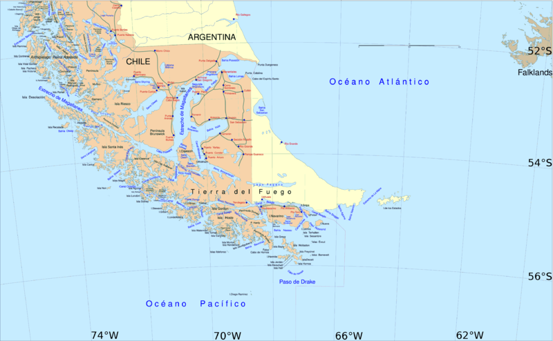
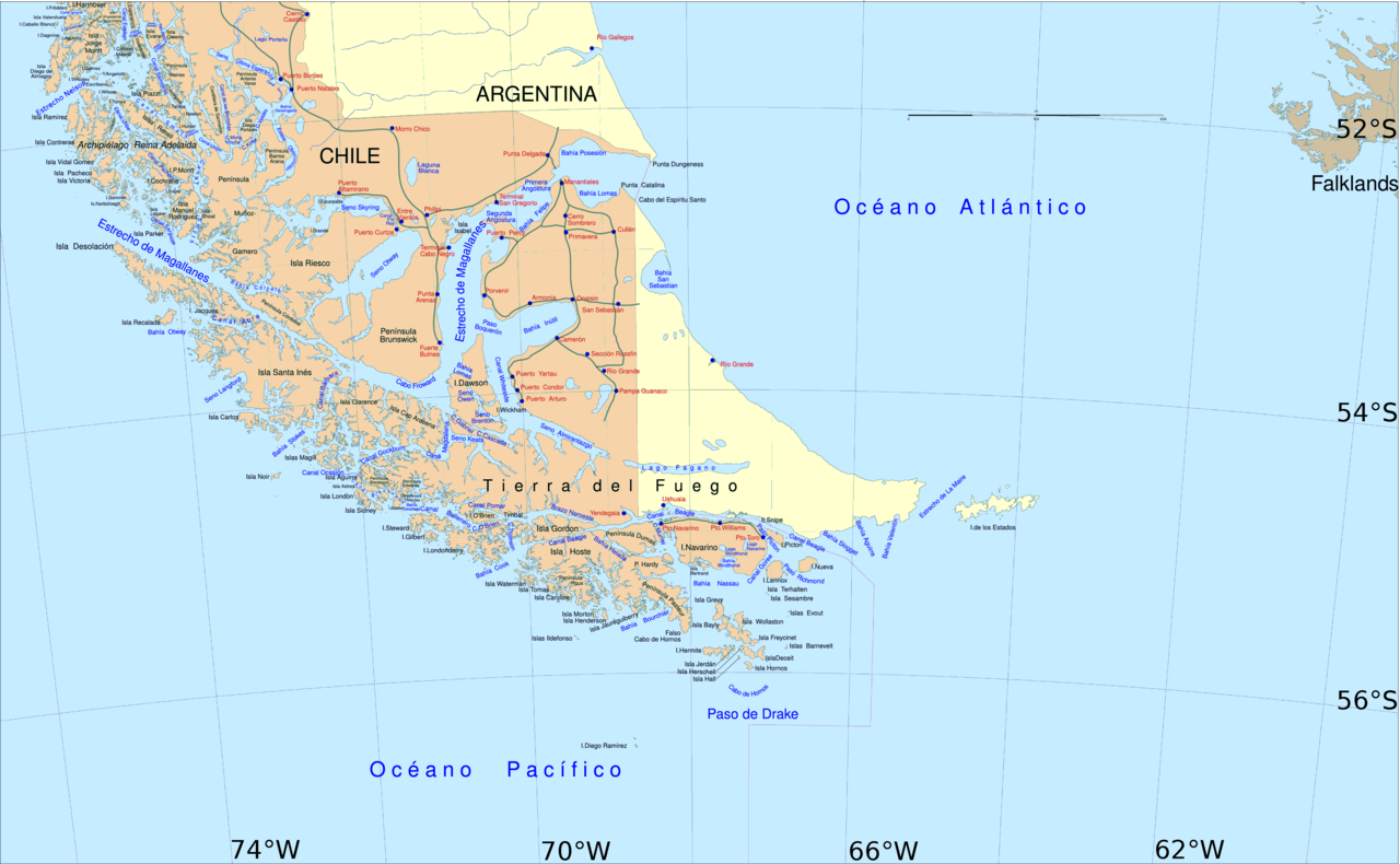
English: Political map of southern Chile and Argentina, from Straits of Magellan to Cape Horn.
Español: Mapa político del sur de Chile y la Argentina, entre el estrecho de Magallanes y el cabo de Hornos. |
||||
| วันที่ | |||||
| แหล่งที่มา | File:Sur2.gif | ||||
| ผู้สร้างสรรค์ | User:Createaccount | ||||
| การอนุญาต (การใช้ไฟล์นี้ใหม่) |
|
||||
| เวอร์ชันอื่น | ไฟล์อื่นที่ใช้ไฟล์นี้: Metula.svg |
การอนุญาตใช้สิทธิ

|
อนุญาตให้คัดลอก แจกจ่ายและ/หรือดัดแปรเอกสารนี้ภายใต้เงื่อนไขของสัญญาอนุญาตเอกสารเสรีของกนู รุ่น 1.2 หรือรุ่นใด ๆ นับจากนี้ที่ออกโดยมูลนิธิซอฟต์แวร์เสรี โดยไม่มีส่วนใดห้ามแก้ไข ไม่มีข้อความปกหน้าและปกหลัง สำเนาของสัญญาอนุญาตรวมอยู่ในส่วนชื่อ สัญญาอนุญาตเอกสารเสรีของกนู |
| ไฟล์นี้อยู่ภายใต้สัญญาอนุญาต ครีเอทีฟคอมมอนส์ แบบแสดงที่มา-อนุญาตแบบเดียวกัน 3.0 ต้นฉบับ | ||
| ||
| ป้ายแสดงสถานะลิขสิทธิ์นี้ถูกเพิ่มเพื่อให้เป็นไปตามการเปลี่ยนแปลงสัญญาอนุญาตของมูลนิธิวิกิมีเดีย จาก GFDL ไปยัง GFDL ควบคู่กับ CC-BY-SA 3.0 |
ประวัติไฟล์
คลิกวันที่/เวลาเพื่อดูไฟล์ที่ปรากฏในขณะนั้น
| วันที่/เวลา | รูปย่อ | ขนาด | ผู้ใช้ | ความเห็น | |
|---|---|---|---|---|---|
| ปัจจุบัน | 21:06, 30 เมษายน 2559 | | 3,859 × 2,383 (596 กิโลไบต์) | Hohum | Cartographic colours |
| 18:09, 3 เมษายน 2556 |  | 3,859 × 2,383 (597 กิโลไบต์) | Keysanger | Margin right and top cropped | |
| 17:47, 3 เมษายน 2556 |  | 3,859 × 2,383 (597 กิโลไบต์) | Keysanger | "Estrecho Nelson" added Bigger Latitude and Longitude within the image empty margin cropped | |
| 02:30, 4 พฤษภาคม 2552 |  | 3,894 × 2,441 (639 กิโลไบต์) | Pitichinaccio | different colour | |
| 02:29, 4 พฤษภาคม 2552 |  | 3,894 × 2,441 (639 กิโลไบต์) | Pitichinaccio | {{Information |Description={{en|1=political map of southern Chile/Argentina: From Straits of Magellan to Cape Horn}} |Source=File:Sur2.gif |Author=User:Createaccount |Date=2008 |Permission={{GFDL-GMT}}} |other_versions=File:Sur2.gif }} <!-- |
หน้าที่มีภาพนี้
หน้าต่อไปนี้ โยงมาที่ภาพนี้:
การใช้ไฟล์ข้ามโครงการ
วิกิอื่นต่อไปนี้ใช้ไฟล์นี้:
- การใช้บน af.wikipedia.org
- การใช้บน als.wikipedia.org
- การใช้บน ar.wikipedia.org
- การใช้บน ast.wikipedia.org
- การใช้บน br.wikipedia.org
- การใช้บน ca.wikipedia.org
- การใช้บน de.wikipedia.org
- การใช้บน de.wiktionary.org
- การใช้บน el.wikipedia.org
- การใช้บน en.wikipedia.org
- Cape Froward
- Porvenir, Chile
- Santa Inés Island
- Puerto Toro
- False Cape Horn
- Puerto del Hambre
- Maritime history of California
- Brunswick Peninsula
- Almirantazgo Fjord
- Fjord of the Mountains
- Primera Angostura
- Aracena Island
- Punta Dúngeness
- Muñoz Gamero Peninsula
- Seno Otway
- Mitre Peninsula
- Marlborough (1876 ship)
ดูการใช้ข้ามโครงการเพิ่มเติมของไฟล์นี้