
ไฟล์:Persia 600ad.jpg
ดูภาพที่มีความละเอียดสูงกว่า (1,098 × 623 พิกเซล, ขนาดไฟล์: 644 กิโลไบต์, ชนิดไมม์: image/jpeg)
| รูปภาพหรือไฟล์เสียงนี้ ต้นฉบับอยู่ที่ คอมมอนส์ รายละเอียดด้านล่าง เป็นข้อความที่แสดงผลจาก ไฟล์ต้นฉบับในคอมมอนส์
|
Rest

|
ภาพแผนที่ทางประวัติศาสตร์นี้ ควรจะถูกสร้างใหม่เป็นกราฟิกส์เวกเตอร์ ซึ่งมีข้อดีอีกหลายประการ ดูเพิ่มเติมที่คอมมอนส์:สื่อต้องการเก็บกวาดสำหรับสารสนเทศเพิ่มเติม หากภาพนี้มีในรูปแบบกราฟิกส์เวกเตอร์อยู่แล้ว กรุณาอัปโหลดและแทนที่แม่แบบนี้ด้วย
{{vector version available|ชื่อภาพใหม่}}
แนะนำเป็นอย่างยิ่งให้ตั้งชื่อไฟล์เวกเตอร์ใหม่นั้นในรูปแบบ "Persia 600ad.svg" แล้วใส่แม่แบบ Vector version available (หรือ Vva) ซึ่งไม่ต้องใช้พารามิเตอร์ ชื่อภาพใหม่ |


ความย่อ
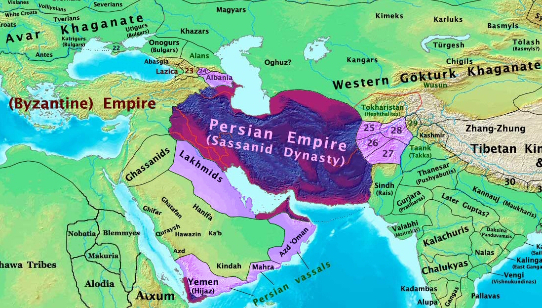
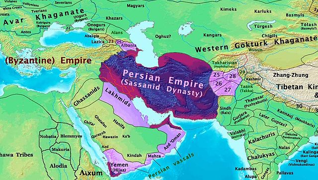
| คำอธิบาย | The Persian Sassanid Empire in 600 AD. |
| วันที่ | |
| แหล่งที่มา | งานของตัว |
| ผู้สร้างสรรค์ | Thomas Lessman (Contact!) |
| การอนุญาต (การใช้ไฟล์นี้ใหม่) |
ข้าพเจ้า ในฐานะผู้ถือลิขสิทธิ์ของภาพหรือสื่อนี้ อนุญาตให้ใช้ภาพหรือสื่อนี้ภายใต้เงื่อนไขต่อไปนี้ ไฟล์นี้อยู่ภายใต้สัญญาอนุญาต ครีเอทีฟคอมมอนส์ แบบแสดงที่มา-อนุญาตแบบเดียวกัน 3.0 ต้นฉบับ
|
| เวอร์ชันอื่น | see below |
Map Summary

Original Source URL: http://www.thomaslessman.com/History/images/East-Hem_600ad.jpg
This map is a zoomed-in version of Thomas Lessman's map of the
East-Hem_600ad.jpg (also available at www.WorldHistoryMaps.info).
The highlighted areas represent the Persian Sassanid Empire and its territories in the year 600 AD (before the Great Romano-Persian war).
Map Source References
Remember, sources often conflict with each other. This map is only as accurate as the information that is available to me. To report any errors or to help further this work, please click here, or email Thomas Lessman at talessman@yis.us
References for information contained in this map:
Other Maps by Thomas Lessman
| Maps of the eastern hemisphere showing history
Bold dates are available on Wikimedia or Wikipedia. | ||
| Primeval | ||
| Ancient
|
·| 600 BC | 550 BC | 527 BC | 500 BC |
400 BC | ·| 1 AD | 50 AD | 100 AD | 200 AD | 300 AD | | |
| Medieval |
·| 500 AD | 565 AD | 600 AD | 700 AD | | |
| Modern |
·| 1500 AD | · * For historical maps of the whole world, | |
Other Info
บันทึกการอัพโหลด
- 2008-01-30 00:27 Talessman 1724×814×8 (267093 bytes) This image is a zoomed-in version of [http://en.wikipedia.org/wiki/Image:East-Hem_600ad.jpg Eastern Hemisphere in 600 AD]. The highlighted area is the Persian Sassanid Empire. [[Image:East-Hem_600ad.jpg|thumb|300px|left|Eastern Hemisphere in 600 AD.]] Author: T
ประวัติไฟล์
คลิกวันที่/เวลาเพื่อดูไฟล์ที่ปรากฏในขณะนั้น
| วันที่/เวลา | รูปย่อ | ขนาด | ผู้ใช้ | ความเห็น | |
|---|---|---|---|---|---|
| ปัจจุบัน | 02:44, 8 ธันวาคม 2558 | | 1,098 × 623 (644 กิโลไบต์) | B | Removed obnoxious label |
| 04:00, 22 สิงหาคม 2551 |  | 1,098 × 623 (813 กิโลไบต์) | Talessman | Updated version of the parent map. This new version features colored areas to highlight the Persian Empire and its vassal states. | |
| 00:25, 29 เมษายน 2551 |  | 1,724 × 814 (261 กิโลไบต์) | Producer | {{Information |Description={{en|This image is a zoomed-in version of [http://en.wikipedia.org/wiki/Image:East-Hem_600ad.jpg Eastern Hemisphere in 600 AD]. The highlighted area is the Sassanid Persian Empire. [[:en:Image:East-Hem_600ad.jpg|thumb|300px|lef |
หน้าที่มีภาพนี้
หน้าต่อไปนี้ โยงมาที่ภาพนี้:
การใช้ไฟล์ข้ามโครงการ
วิกิอื่นต่อไปนี้ใช้ไฟล์นี้:
- การใช้บน ar.wikipedia.org
- การใช้บน as.wikipedia.org
- การใช้บน azb.wikipedia.org
- การใช้บน bn.wikipedia.org
- การใช้บน ca.wikipedia.org
- การใช้บน cs.wikipedia.org
- การใช้บน de.wikipedia.org
- การใช้บน el.wikipedia.org
- การใช้บน en.wikipedia.org
- การใช้บน es.wikipedia.org
- การใช้บน fa.wikipedia.org
- การใช้บน fr.wikipedia.org
- การใช้บน hi.wikipedia.org
- การใช้บน hy.wikipedia.org
- การใช้บน hyw.wikipedia.org
- การใช้บน id.wikipedia.org
- การใช้บน incubator.wikimedia.org
- การใช้บน is.wikipedia.org
- การใช้บน it.wikipedia.org
- การใช้บน ja.wikipedia.org
ดูการใช้ข้ามโครงการเพิ่มเติมของไฟล์นี้