
ไฟล์:Map of the partition of the Kingdom of Poland and the Grand Duchy of Lithuania from 1799.jpg

ขนาดของตัวอย่างนี้: 669 × 600 พิกเซล ความละเอียดอื่น: 268 × 240 พิกเซล | 535 × 480 พิกเซล | 856 × 768 พิกเซล | 1,142 × 1,024 พิกเซล | 2,284 × 2,048 พิกเซล | 6,330 × 5,677 พิกเซล
ดูภาพที่มีความละเอียดสูงกว่า (6,330 × 5,677 พิกเซล, ขนาดไฟล์: 6.83 เมกะไบต์, ชนิดไมม์: image/jpeg)
| รูปภาพหรือไฟล์เสียงนี้ ต้นฉบับอยู่ที่ คอมมอนส์ รายละเอียดด้านล่าง เป็นข้อความที่แสดงผลจาก ไฟล์ต้นฉบับในคอมมอนส์
|
ความย่อ
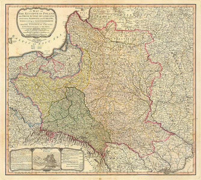
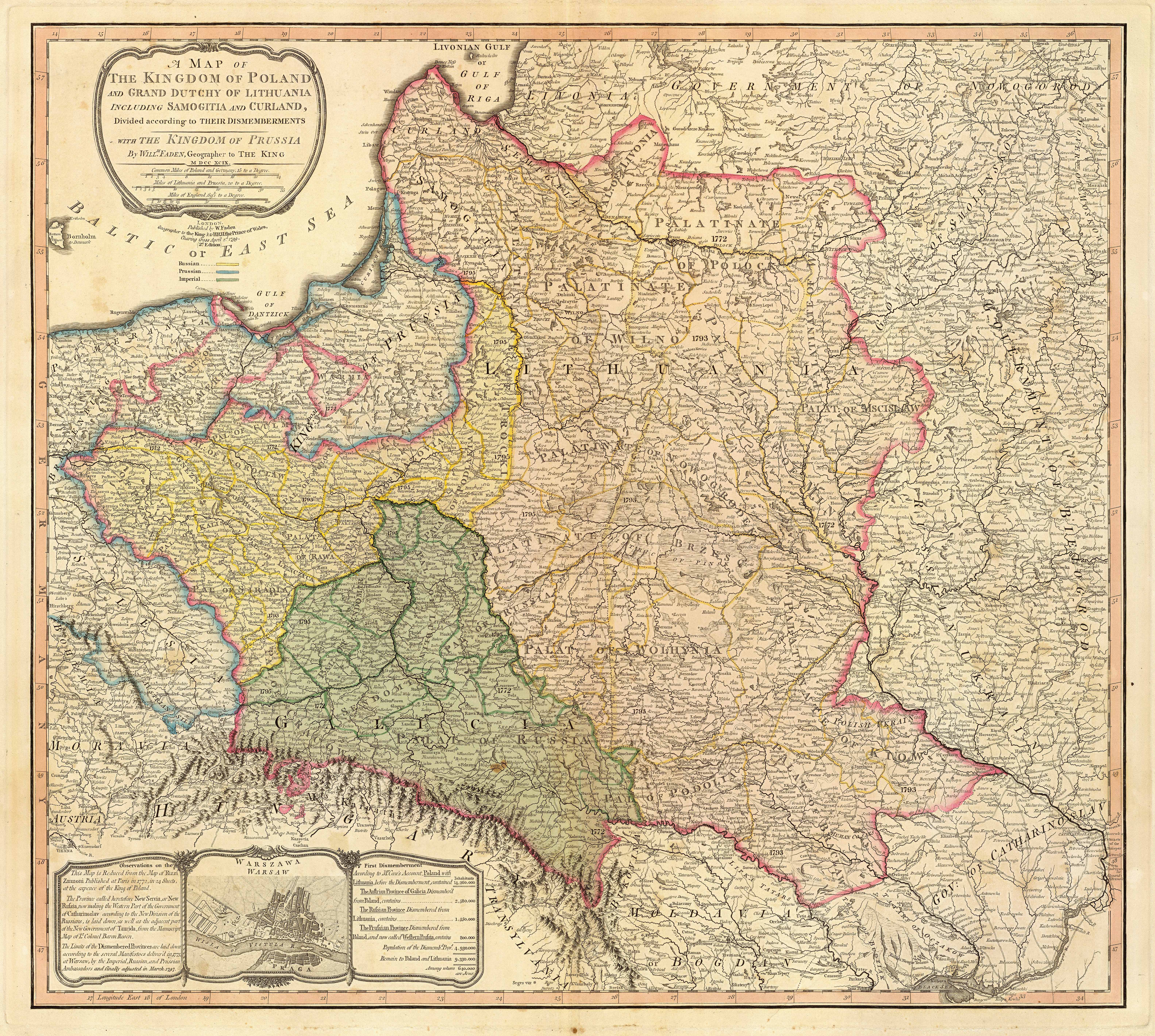
| คำอธิบาย | Title: "A map of the Kingdom of Poland and the Grand Duchy of Lithuania including Samogitia and Curland divided according to their dismemberments with the Kingdom of Prussia". A map from 1799 showing how the Polish-Lithuanian Commonwealth was partitioned in 1765-1795 between Prussia, Austria, and Russia. This is an extremely detailed map which lists all the cities and small towns and labels the regions according to their English names. The boundaries former Polish-Lithuanian Commonwealth colored light red. The areas taken by Prussia are colored yellow, those taken by Austria colored green, and those taken by Russia are colored beige. Prussia itself is bordered in blue. Eastern Pomerania and Warmia are shown as part of Prussia but bordered in red as well. | ||||||||||||||||||||||
| วันที่ | |||||||||||||||||||||||
| แหล่งที่มา | http://www.belarusguide.com/images/maps/Kokosha/POlonia&Lituania-1799.jpg | ||||||||||||||||||||||
| ผู้สร้างสรรค์ |
|
||||||||||||||||||||||
การอนุญาตใช้สิทธิ
|
งานนี้เป็นสาธารณสมบัติ ในประเทศต้นกำเนิดและประเทศอื่น ๆ ที่ระยะเวลาการคุ้มครองลิขสิทธิ์น้อยกว่า 100 ปีหลังจากผู้สร้างสรรค์งานเสียชีวิต. | |
| ไฟล์นี้ได้ถูกระบุว่าไม่มีข้อจำกัดภายใต้กฎหมายลิขสิทธิ์ รวมถึงสิทธิที่เกี่ยวข้องและที่ใกล้เคียงกัน | |
ประวัติไฟล์
คลิกวันที่/เวลาเพื่อดูไฟล์ที่ปรากฏในขณะนั้น
| วันที่/เวลา | รูปย่อ | ขนาด | ผู้ใช้ | ความเห็น | |
|---|---|---|---|---|---|
| ปัจจุบัน | 12:04, 23 กันยายน 2550 | | 6,330 × 5,677 (6.83 เมกะไบต์) | Archaeogenetics | {{Information |Description=Title: "A map of the Kingdom of Poland and the Grand Duchy of Lithuania including Samogitia and Curland divided according to their dismemberments with the Kingdom of Prussia". A map from 1799 showing how the Polish-Lithuanian Co |
หน้าที่มีภาพนี้
หน้าต่อไปนี้ โยงมาที่ภาพนี้:
การใช้ไฟล์ข้ามโครงการ
วิกิอื่นต่อไปนี้ใช้ไฟล์นี้:
- การใช้บน en.wikipedia.org
- การใช้บน et.wikipedia.org
- การใช้บน lt.wikipedia.org
- การใช้บน lt.wikibooks.org
- การใช้บน pnb.wikipedia.org
- การใช้บน uk.wikipedia.org
- การใช้บน ur.wikipedia.org
- การใช้บน zh.wikipedia.org