
ไฟล์:Lava Flow on Volcán de Fuego, 2016.jpg
ไม่มีภาพที่มีรายละเอียดสูงกว่านี้
Lava_Flow_on_Volcán_de_Fuego,_2016.jpg (720 × 480 พิกเซล, ขนาดไฟล์: 315 กิโลไบต์, ชนิดไมม์: image/jpeg)
| รูปภาพหรือไฟล์เสียงนี้ ต้นฉบับอยู่ที่ คอมมอนส์ รายละเอียดด้านล่าง เป็นข้อความที่แสดงผลจาก ไฟล์ต้นฉบับในคอมมอนส์
|
| คำอธิบาย |
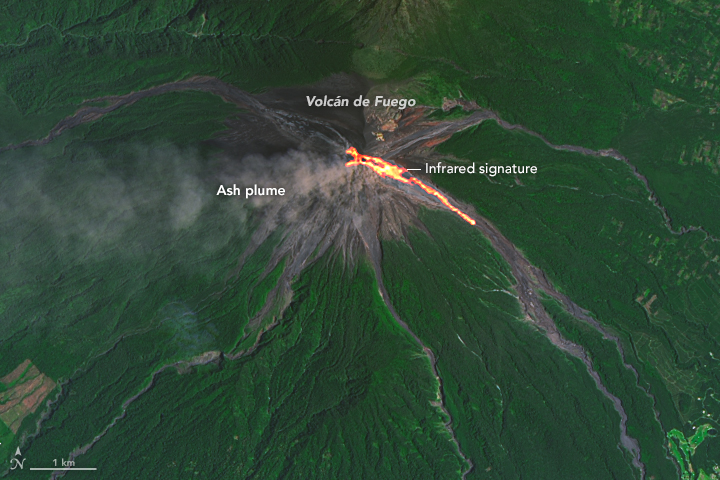
English: On September 7, 2016, the Operational Land Imager (OLI) on Landsat 8 captured this image of lava spilling down the slopes of Guatemala’s Volcán de Fuego, one of Central America’s most active volcanoes.
According to reporting from the Instituto Nacional de Sismologia, Vulcanologia, Meteorologia, e Hidrologia (INSIVUMEH), the latest bout of activity began on September 4, when lava rose as high as 200 meters (650 feet) above Fuego’s crater rim. Plumes of ash have reached heights of about 850 meters (2,800 feet). The image is a composite of natural color (OLI bands 4-3-2) and shortwave Infrared (OLI band 7). Shortwave infrared light (SWIR) is invisible to the naked eye, but strong SWIR signals indicate increased temperatures. The volcano is located about 70 kilometers (40 miles) west of Guatemala City, Guatemala. |
|||||
| วันที่ | acquired September 7, 2016 | |||||
| แหล่งที่มา | http://earthobservatory.nasa.gov/IOTD/view.php?id=88722&src=eoa-iotd | |||||
| ผู้สร้างสรรค์ | NASA Earth Observatory image by Joshua Stevens, using Landsat data from the U.S. Geological Survey. | |||||
| การอนุญาต (การใช้ไฟล์นี้ใหม่) |
|

ประวัติไฟล์
คลิกวันที่/เวลาเพื่อดูไฟล์ที่ปรากฏในขณะนั้น
| วันที่/เวลา | รูปย่อ | ขนาด | ผู้ใช้ | ความเห็น | |
|---|---|---|---|---|---|
| ปัจจุบัน | 03:54, 24 กันยายน 2559 | | 720 × 480 (315 กิโลไบต์) | Tillman | {{Information |Description ={{en|1=On September 7, 2016, the Operational Land Imager (OLI) on Landsat 8 captured this image of lava spilling down the slopes of Guatemala’s Volcán de Fuego, one of Central America’s most active volcanoes. Accord... |
หน้าที่มีภาพนี้
หน้าต่อไปนี้ โยงมาที่ภาพนี้:
การใช้ไฟล์ข้ามโครงการ
วิกิอื่นต่อไปนี้ใช้ไฟล์นี้:
- การใช้บน ar.wikipedia.org
- การใช้บน id.wikipedia.org
- การใช้บน mk.wikipedia.org
- การใช้บน pt.wikipedia.org
- การใช้บน sl.wikipedia.org
- การใช้บน ta.wikipedia.org
- การใช้บน vi.wikipedia.org