
ไฟล์:Lake Huron bathymetry map.png
ดูภาพที่มีความละเอียดสูงกว่า (936 × 1,024 พิกเซล, ขนาดไฟล์: 1.35 เมกะไบต์, ชนิดไมม์: image/png)
| รูปภาพหรือไฟล์เสียงนี้ ต้นฉบับอยู่ที่ คอมมอนส์ รายละเอียดด้านล่าง เป็นข้อความที่แสดงผลจาก ไฟล์ต้นฉบับในคอมมอนส์
|
ความย่อ
| คำอธิบาย |
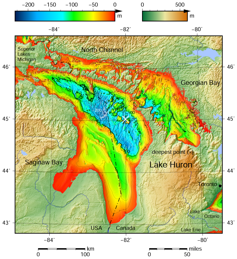
English: Lake Huron bathymetric shaded relief map contoured with interval 25 m (100 m with thicker lines). The deepest point is marked with "×". For land the vertical datum is sea level, for bathymetry low water datum of the lake. The map was created using the Generic Mapping Tools, GMT, version 5.1.1. |
| วันที่ | |
| แหล่งที่มา |
Own work using: the following Public Domain datasets (grids):
The coordinates of deepest point are taken from the NOAA Great LakesEnvironmental Research Laboratory webpage (www.glerl.noaa.gov/, kml file Google Earth Great Lakes Tour). |
| ผู้สร้างสรรค์ | Darekk2 using the Great Lakes Bathymetry and GLOBE tiles |
| เวอร์ชันอื่น |
|

การอนุญาตใช้สิทธิ
Attribution (in addition to the author of this map):
The NGDC in it's copyright notice says:
As required by 17 U.S.C. 403, third parties producing copyrighted works consisting predominantly of the material produced by U.S. government agencies must provide notice with such work(s) identifying the U.S. Government material incorporated and stating that such material is not subject to copyright protection within the United States. (...)
(for credits see the Source section).
and Great Lakes Bathymetry and GLOBE
(see above and the Source section)
- คุณสามารถ:
- ที่จะแบ่งปัน – ที่จะทำสำเนา แจกจ่าย และส่งงานดังกล่าวต่อไป
- ที่จะเรียบเรียงใหม่ – ที่จะดัดแปลงงานดังกล่าว
- ภายใต้เงื่อนไขต่อไปนี้:
- แสดงที่มา – คุณต้องให้เกียรติเจ้าของงานอย่างเหมาะสม โดยเพิ่มลิงก์ไปยังสัญญาอนุญาต และระบุหากมีการเปลี่ยนแปลง คุณอาจทำเช่นนี้ได้ในรูปแบบใดก็ได้ตามควร แต่ต้องไม่ใช่ในลักษณะที่แนะว่าผู้ให้อนุญาตสนับสนุนคุณหรือการใช้งานของคุณ
- อนุญาตแบบเดียวกัน – หากคุณดัดแปลง เปลี่ยนรูป หรือต่อเติมงานนี้ คุณต้องใช้สัญญาอนุญาตแบบเดียวกันหรือแบบที่เหมือนกับสัญญาอนุญาตที่ใช้กับงานนี้เท่านั้น
ประวัติไฟล์
คลิกวันที่/เวลาเพื่อดูไฟล์ที่ปรากฏในขณะนั้น
| วันที่/เวลา | รูปย่อ | ขนาด | ผู้ใช้ | ความเห็น | |
|---|---|---|---|---|---|
| ปัจจุบัน | 19:21, 10 พฤษภาคม 2558 | | 936 × 1,024 (1.35 เมกะไบต์) | Darekk2 | a small island in NE Michigan |
| 01:00, 9 พฤษภาคม 2558 |  | 936 × 1,024 (1.35 เมกะไบต์) | Darekk2 | forgot about few islands in south ... !! | |
| 23:57, 8 พฤษภาคม 2558 |  | 936 × 1,024 (1.35 เมกะไบต์) | Darekk2 | thicker deepest point mark | |
| 22:27, 8 พฤษภาคม 2558 |  | 936 × 1,024 (1.35 เมกะไบต์) | Darekk2 | User created page with UploadWizard |
หน้าที่มีภาพนี้
หน้าต่อไปนี้ โยงมาที่ภาพนี้:
การใช้ไฟล์ข้ามโครงการ
วิกิอื่นต่อไปนี้ใช้ไฟล์นี้:
- การใช้บน ban.wikipedia.org
- การใช้บน en.wikipedia.org
- การใช้บน id.wikipedia.org
- การใช้บน kn.wikipedia.org
- การใช้บน vi.wikipedia.org
- การใช้บน www.wikidata.org