
ไฟล์:Egbert of Wessex map.jpg
ขนาดของตัวอย่างนี้: 574 × 599 พิกเซล ความละเอียดอื่น: 230 × 240 พิกเซล | 460 × 480 พิกเซล | 702 × 733 พิกเซล
ดูภาพที่มีความละเอียดสูงกว่า (702 × 733 พิกเซล, ขนาดไฟล์: 136 กิโลไบต์, ชนิดไมม์: image/jpeg)
| รูปภาพหรือไฟล์เสียงนี้ ต้นฉบับอยู่ที่ คอมมอนส์ รายละเอียดด้านล่าง เป็นข้อความที่แสดงผลจาก ไฟล์ต้นฉบับในคอมมอนส์
|
ความย่อ
| คำอธิบาย |
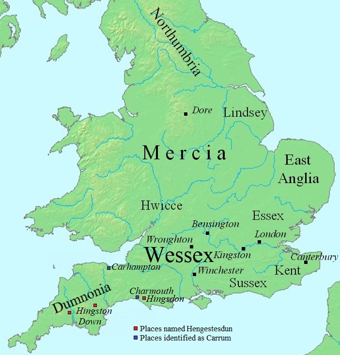
English: Map of England, showing places of interest to the Egbert of Wessex article.
The file was created using DMIS. On that site it is stated that "We do not claim copyright on the images, so you can use them for Wikipedia." en:Commons:category:Maps of England en:Commons:category:Wessex |
| วันที่ | 1 กันยายน พ.ศ. 2550 (original upload date) |
| แหล่งที่มา | นำเข้าจาก en.wikipedia มายังคอมมอนส์ |
| ผู้สร้างสรรค์ | Mike Christie ที่ วิกิพีเดียภาษาอังกฤษ |
| เวอร์ชันอื่น | File:Map Egbert of Wessex.svg |
การอนุญาตใช้สิทธิ
| งานนี้ได้ถูกเผยแพร่สู่สาธารณสมบัติโดยเจ้าของ Mike Christie ที่ วิกิพีเดียภาษาอังกฤษ ซึ่งมีผลทั่วโลก ในบางประเทศ การกระทำดังกล่าวอาจไม่สามารถทำได้ตามกฎหมาย Mike Christie อนุญาตให้ทุกคนมีสิทธิ์ในการใช้ไฟล์นี้ในทุกเหตุผลการใช้ โดยไม่มีมีเงื่อนไข เว้นแต่กฎหมายไม่อนุญาตให้ทำเช่นนั้น |
บันทึกการอัพโหลด
The original description page was here. All following user names refer to en.wikipedia.
- 2007-09-09 17:57 Mike Christie 702×733×8 (87999 bytes)
- 2007-09-01 17:40 Mike Christie 602×628×8 (70407 bytes) == Summary == Map of southwestern England and south Wales, showing places visited by Asser. The file was created using [http://www.demis.nl/home/pages/home.htm DMIS]. On that site it is [http://support.demis.nl/forums/thread/1295.aspx stated] that "We d
ประวัติไฟล์
คลิกวันที่/เวลาเพื่อดูไฟล์ที่ปรากฏในขณะนั้น
| วันที่/เวลา | รูปย่อ | ขนาด | ผู้ใช้ | ความเห็น | |
|---|---|---|---|---|---|
| ปัจจุบัน | 20:01, 9 กรกฎาคม 2565 | | 702 × 733 (136 กิโลไบต์) | Bodrugan | fixing a few of the place names on the map |
| 00:40, 29 ตุลาคม 2550 |  | 702 × 733 (86 กิโลไบต์) | Ekki01 | {{Information |Description=Map of England, showing places of interest to the en:Egbert of Wessex article. The file was created using [http://www.demis.nl/home/pages/home.htm DMIS]. On that site it is [http://support.demis.nl/forums/thread/1295.aspx |
หน้าที่มีภาพนี้
หน้าต่อไปนี้ โยงมาที่ภาพนี้:
การใช้ไฟล์ข้ามโครงการ
วิกิอื่นต่อไปนี้ใช้ไฟล์นี้:
- การใช้บน br.wikipedia.org
- การใช้บน ca.wikipedia.org
- การใช้บน cs.wikipedia.org
- การใช้บน de.wikipedia.org
- การใช้บน el.wikipedia.org
- การใช้บน en.wikipedia.org
- การใช้บน eo.wikipedia.org
- การใช้บน es.wikipedia.org
- การใช้บน fy.wikipedia.org
- การใช้บน it.wikipedia.org
- การใช้บน ja.wikipedia.org
- การใช้บน lt.wikipedia.org
- การใช้บน nl.wikipedia.org
- การใช้บน no.wikipedia.org
- การใช้บน pt.wikipedia.org
- การใช้บน ru.wikipedia.org
- การใช้บน simple.wikipedia.org
- การใช้บน sv.wikipedia.org