
ไฟล์:Connecticut River Map.png
ขนาดของตัวอย่างนี้: 448 × 600 พิกเซล ความละเอียดอื่น: 179 × 240 พิกเซล | 578 × 774 พิกเซล
ดูภาพที่มีความละเอียดสูงกว่า (578 × 774 พิกเซล, ขนาดไฟล์: 58 กิโลไบต์, ชนิดไมม์: image/png)
| รูปภาพหรือไฟล์เสียงนี้ ต้นฉบับอยู่ที่ คอมมอนส์ รายละเอียดด้านล่าง เป็นข้อความที่แสดงผลจาก ไฟล์ต้นฉบับในคอมมอนส์
|
ความย่อ
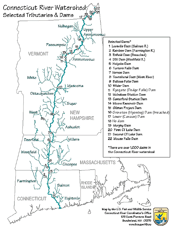
| คำอธิบาย | Map of the Connecticut River, New England, USA. This map was prepared by the United States Fish and Wildlife Service, and as a product of the United States Government is in the public domain and not subject to copyright restrictions. | |||
| แหล่งที่มา | Originally from en.wikipedia; description page is/was here. Original uploader was Daderot ที่ วิกิพีเดียภาษาอังกฤษ | |||
| ผู้สร้างสรรค์ | USGov | |||
| การอนุญาต (การใช้ไฟล์นี้ใหม่) |
|


|
ภาพแผนที่การขนส่งนี้ ควรจะถูกสร้างใหม่เป็นกราฟิกส์เวกเตอร์ ซึ่งมีข้อดีอีกหลายประการ ดูเพิ่มเติมที่คอมมอนส์:สื่อต้องการเก็บกวาดสำหรับสารสนเทศเพิ่มเติม หากภาพนี้มีในรูปแบบกราฟิกส์เวกเตอร์อยู่แล้ว กรุณาอัปโหลดและแทนที่แม่แบบนี้ด้วย
{{vector version available|ชื่อภาพใหม่}}
แนะนำเป็นอย่างยิ่งให้ตั้งชื่อไฟล์เวกเตอร์ใหม่นั้นในรูปแบบ "Connecticut River Map.svg" แล้วใส่แม่แบบ Vector version available (หรือ Vva) ซึ่งไม่ต้องใช้พารามิเตอร์ ชื่อภาพใหม่ |
บันทึกการอัพโหลด
| วันที่/เวลา | ขนาด | ผู้ใช้ | ความเห็น |
|---|---|---|---|
| 6 มกราคม พ.ศ. 2551, 16:02:00 | 580 × 778 (61343 bytes) | Gridge (คุย · ส่วนร่วม) | {{Information |Description=Map of the Connecticut River, New England, USA. This map was prepared by the United States Fish and Wildlife Service, and as a product of the United States Government is in the public domain and not subject to copyright restrict |
ประวัติไฟล์
คลิกวันที่/เวลาเพื่อดูไฟล์ที่ปรากฏในขณะนั้น
| วันที่/เวลา | รูปย่อ | ขนาด | ผู้ใช้ | ความเห็น | |
|---|---|---|---|---|---|
| ปัจจุบัน | 15:26, 10 มีนาคม 2567 | | 578 × 774 (58 กิโลไบต์) | Lojwe | Cropped < 1 % horizontally, 1 % vertically using CropTool with precise mode. |
| 11:45, 25 พฤศจิกายน 2557 |  | 580 × 778 (74 กิโลไบต์) | GifTagger | Bot: Converting file to superior PNG file. (Source: Connecticut_River_Map.gif). This GIF was problematic due to non-greyscale color table. |
หน้าที่มีภาพนี้
หน้าต่อไปนี้ โยงมาที่ภาพนี้:
การใช้ไฟล์ข้ามโครงการ
วิกิอื่นต่อไปนี้ใช้ไฟล์นี้:
- การใช้บน bg.wikipedia.org
- การใช้บน cs.wikipedia.org
- การใช้บน da.wikipedia.org
- การใช้บน de.wikipedia.org
- การใช้บน en.wikipedia.org
- การใช้บน es.wikipedia.org
- การใช้บน fi.wikipedia.org
- การใช้บน fr.wikipedia.org
- การใช้บน fy.wikipedia.org
- การใช้บน he.wikipedia.org
- การใช้บน incubator.wikimedia.org
- การใช้บน it.wikipedia.org
- การใช้บน ja.wikipedia.org
- การใช้บน nl.wikipedia.org
- การใช้บน pt.wikipedia.org
- การใช้บน ru.wikipedia.org
- การใช้บน simple.wikipedia.org
- การใช้บน sv.wikipedia.org
- การใช้บน sw.wikipedia.org
- การใช้บน ta.wikipedia.org
- การใช้บน www.wikidata.org
- การใช้บน zh.wikipedia.org