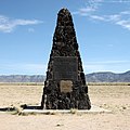
ไฟล์:Trinity Site Obelisk National Historic Landmark.jpg

ไม่รองรับเนื้อหาของหน้าในภาษาอื่น
จากวิกิพีเดีย สารานุกรมเสรี

ดูภาพที่มีความละเอียดสูงกว่า(2,300 × 2,300 พิกเซล, ขนาดไฟล์: 3.49 เมกะไบต์, ชนิดไมม์: image/jpeg)

Wikimedia Commons logo รูปภาพหรือไฟล์เสียงนี้ ต้นฉบับอยู่ที่ คอมมอนส์ รายละเอียดด้านล่าง เป็นข้อความที่แสดงผลจาก ไฟล์ต้นฉบับในคอมมอนส์
คอมมอนส์เป็นเว็บไซต์ในโครงการสำหรับเก็บรวบรวมสื่อเสรี ที่ คุณสามารถช่วยได้

This is an image of a place or building that is listed on the National Register of Historic Places in the United States of America. Its reference number is 66000493.

คำอธิบาย
English: Trinity Site obelisk.

The black plaque on top reads:

Trinity Site
Where The World's First Nuclear Device Was Exploded On July 16, 1945
Erected 1965 White Sands Missile Range J. Frederick Thorlin Major General U.S. Army Commanding

The gold plaque below it declares the site a National Historic Landmark, and reads:

Trinity Site has been designated a National Historical Landmark
This Site Possesses National Significance In Commemorating The History of the United States of America
1975 National Park Service United States Department of the Interior

วันที่
แหล่งที่มา Flickr: Trinity Site Obelisk National Historic Landmark
ผู้สร้างสรรค์ Samat Jain
การอนุญาต
(การใช้ไฟล์นี้ใหม่)
This image, which was originally posted to Flickr, was uploaded to Commons using Flickr upload bot on 13 มกราคม พ.ศ. 2554, 14:54 by Bomazi. On that date, it was confirmed to be licensed under the terms of the license indicated.
w:th:ครีเอทีฟคอมมอนส์
แสดงที่มา อนุญาตแบบเดียวกัน
คุณสามารถ:
  • ที่จะแบ่งปัน – ที่จะทำสำเนา แจกจ่าย และส่งงานดังกล่าวต่อไป
  • ที่จะเรียบเรียงใหม่ – ที่จะดัดแปลงงานดังกล่าว
ภายใต้เงื่อนไขต่อไปนี้:
  • แสดงที่มา – คุณต้องให้เกียรติเจ้าของงานอย่างเหมาะสม โดยเพิ่มลิงก์ไปยังสัญญาอนุญาต และระบุหากมีการเปลี่ยนแปลง คุณอาจทำเช่นนี้ได้ในรูปแบบใดก็ได้ตามควร แต่ต้องไม่ใช่ในลักษณะที่แนะว่าผู้ให้อนุญาตสนับสนุนคุณหรือการใช้งานของคุณ
  • อนุญาตแบบเดียวกัน – หากคุณดัดแปลง เปลี่ยนรูป หรือต่อเติมงานนี้ คุณต้องใช้สัญญาอนุญาตแบบเดียวกันหรือแบบที่เหมือนกับสัญญาอนุญาตที่ใช้กับงานนี้เท่านั้น
The memorial plaque itself is a work of the US Federal government. See White Sands NM: An Administrative History (Chapter 6)
Public domain This image or media file contains material based on a work of a National Park Service employee, created as part of that person's official duties. As a work of the U.S. federal government, such work is in the public domain in the United States. See the NPS website and NPS copyright policy for more information.
ตำแหน่งที่ตั้งกล้อง33° 40′ 38.13″ เหนือ, 106° 28′ 31.64″ ตะวันตก Kartographer map based on OpenStreetMap.ภาพนี้และภาพอื่น ๆ ณ สถานที่เดียวกันที่ OpenStreetMapinfo

คำบรรยายโดยย่อ

เพิ่มคำบรรยายทรรทัดเดียวเพื่อขยายความว่าไฟล์นี้มีอะไร

ไอเทมที่แสดงอยู่ในไฟล์นี้

ประกอบด้วย

Trinity Site อังกฤษ

33°40'38.129"N, 106°28'31.638"W

location of creation อังกฤษ

Socorro County อังกฤษ

exposure time อังกฤษ

0.004 วินาที

f-number อังกฤษ

10

focal length อังกฤษ

20 มิลลิเมตร

ISO speed อังกฤษ

100

MIME type อังกฤษ

image/jpeg

ประวัติไฟล์

คลิกวันที่/เวลาเพื่อดูไฟล์ที่ปรากฏในขณะนั้น

วันที่/เวลารูปย่อขนาดผู้ใช้ความเห็น
ปัจจุบัน01:29, 17 กรกฎาคม 2556รูปย่อสำหรับรุ่นเมื่อ 01:29, 17 กรกฎาคม 25562,300 × 2,300 (3.49 เมกะไบต์)SoerfmCrop, contrast
21:55, 13 มกราคม 2554รูปย่อสำหรับรุ่นเมื่อ 21:55, 13 มกราคม 25542,530 × 2,530 (4.09 เมกะไบต์)Flickr upload botUploaded from http://flickr.com/photo/99842842@N00/5079553260 using Flickr upload bot

หน้าต่อไปนี้ โยงมาที่ภาพนี้:

การใช้ไฟล์ข้ามโครงการ

วิกิอื่นต่อไปนี้ใช้ไฟล์นี้:

ข้อมูลเกี่ยวกับภาพ