
ไฟล์:Polandmap cia gdansk.png
ไม่มีภาพที่มีรายละเอียดสูงกว่านี้
Polandmap_cia_gdansk.png (246 × 400 พิกเซล, ขนาดไฟล์: 20 กิโลไบต์, ชนิดไมม์: image/png)
| รูปภาพหรือไฟล์เสียงนี้ ต้นฉบับอยู่ที่ คอมมอนส์ รายละเอียดด้านล่าง เป็นข้อความที่แสดงผลจาก ไฟล์ต้นฉบับในคอมมอนส์
|
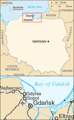
Map of Poland showing relative position of Gdansk, Gdynia and Sopot.
- Mapping from CIA World Factbook and United Nations map of Poland - see http://www.un.org/Depts/Cartographic/map/profile/poland.pdf
- Composited by ChrisO, Feb 18, 2004
CIA World Factbook
This image is a map or flag taken and/or modified from the Central Intelligence Agency's World Factbook. Under United States copyright law, all information and images from the World Factbook are in the public domain.
This image is in the public domain because it contains materials that originally came from the United States Central Intelligence Agency's World Factbook.
|
 |
ประวัติไฟล์
คลิกวันที่/เวลาเพื่อดูไฟล์ที่ปรากฏในขณะนั้น
| วันที่/เวลา | รูปย่อ | ขนาด | ผู้ใช้ | ความเห็น | |
|---|---|---|---|---|---|
| ปัจจุบัน | 00:13, 10 กรกฎาคม 2548 | | 246 × 400 (20 กิโลไบต์) | Michiel1972 | Map of Poland showing relative position of Gdansk, Gdynia and Sopot. * Mapping from CIA World Factbook and United Nations map of Poland - see http://www.un.org/Depts/Cartographic/map/profile/poland.pdf * Composited by ChrisO, Feb 18, 2004 CIA W |
หน้าที่มีภาพนี้
หน้าต่อไปนี้ โยงมาที่ภาพนี้:
การใช้ไฟล์ข้ามโครงการ
วิกิอื่นต่อไปนี้ใช้ไฟล์นี้:
- การใช้บน en.wikipedia.org
- การใช้บน fi.wikipedia.org
- การใช้บน fr.wikipedia.org
- การใช้บน incubator.wikimedia.org