
ไฟล์:Pattaya Bay Panorama.jpg

ขนาดของตัวอย่างนี้: 800 × 121 พิกเซล ความละเอียดอื่น: 320 × 48 พิกเซล | 640 × 96 พิกเซล | 1,024 × 154 พิกเซล | 1,280 × 193 พิกเซล | 2,560 × 386 พิกเซล | 30,000 × 4,521 พิกเซล
ดูภาพที่มีความละเอียดสูงกว่า (30,000 × 4,521 พิกเซล, ขนาดไฟล์: 37.41 เมกะไบต์, ชนิดไมม์: image/jpeg)
| รูปภาพหรือไฟล์เสียงนี้ ต้นฉบับอยู่ที่ คอมมอนส์ รายละเอียดด้านล่าง เป็นข้อความที่แสดงผลจาก ไฟล์ต้นฉบับในคอมมอนส์
|
| Warning | The original file is very high-resolution. It might not load properly or could cause your browser to freeze when opened at full size. |
|---|
ความย่อ
| คำอธิบาย |
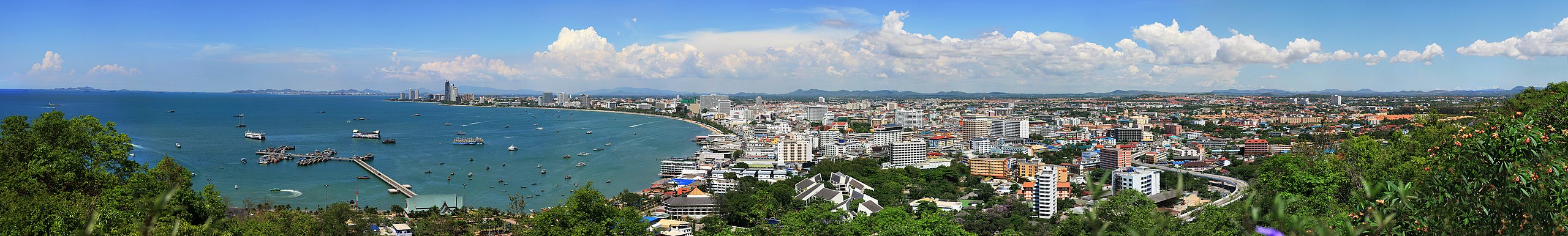
English: Pattaya Bay Panorama, A great panorama on one of the clearest days I have ever seen in Pattaya City. This picture was taken with over 100 shots and then stitched together to form one huge panorama. The day this photo was taken it was exceptionally clear and the port of Laem Chabang is clearly visible at 15 kilometers (9.3 miles) away. The big mountains of Chonburi are also visible at around 45 kilometer (28 miles) away. |
| วันที่ | |
| แหล่งที่มา | งานของตัว |
| ผู้สร้างสรรค์ | D. Nijpels |
| การอนุญาต (การใช้ไฟล์นี้ใหม่) |
Copyright ©2009 D. Nijpels Summary: In using this image or any subsequent derivatives of it, you are required to release the image under the same license. As such, any reproduction of this image, in any medium, must appear with a copy of, or full URL of the license. Attribution of this image to the author (Danny Nijpels) is required in a prominent location near to the image. No other conditions may be added to, or removed from this license without the permission of the author and copyright holder. Please review the full license requirements carefully before using this image. If you would like to clarify the terms of the license or negotiate less restrictive commercial licensing outside of the bounds of GFDL/CC-BY-SA, please contact me by email, or if you don't have a Wikipedia account you can leave a message on my talk page with your contact details and your request. |
| เวอร์ชันอื่น | [Original Version 243 MegaPixel Offline] |
| ตำแหน่งที่ตั้งกล้อง | | ภาพนี้และภาพอื่น ๆ ณ สถานที่เดียวกันที่ OpenStreetMap |
|---|
การอนุญาตใช้สิทธิ
ข้าพเจ้า ในฐานะผู้ถือลิขสิทธิ์ของภาพหรือสื่อนี้ อนุญาตให้ใช้ภาพหรือสื่อนี้ภายใต้เงื่อนไขต่อไปนี้
ไฟล์นี้อยู่ภายใต้สัญญาอนุญาต ครีเอทีฟคอมมอนส์ แบบแสดงที่มา-อนุญาตแบบเดียวกัน 3.0 ต้นฉบับ
- คุณสามารถ:
- ที่จะแบ่งปัน – ที่จะทำสำเนา แจกจ่าย และส่งงานดังกล่าวต่อไป
- ที่จะเรียบเรียงใหม่ – ที่จะดัดแปลงงานดังกล่าว
- ภายใต้เงื่อนไขต่อไปนี้:
- แสดงที่มา – คุณต้องให้เกียรติเจ้าของงานอย่างเหมาะสม โดยเพิ่มลิงก์ไปยังสัญญาอนุญาต และระบุหากมีการเปลี่ยนแปลง คุณอาจทำเช่นนี้ได้ในรูปแบบใดก็ได้ตามควร แต่ต้องไม่ใช่ในลักษณะที่แนะว่าผู้ให้อนุญาตสนับสนุนคุณหรือการใช้งานของคุณ
- อนุญาตแบบเดียวกัน – หากคุณดัดแปลง เปลี่ยนรูป หรือต่อเติมงานนี้ คุณต้องใช้สัญญาอนุญาตแบบเดียวกันหรือแบบที่เหมือนกับสัญญาอนุญาตที่ใช้กับงานนี้เท่านั้น

|
อนุญาตให้คัดลอก แจกจ่ายและ/หรือดัดแปรเอกสารนี้ภายใต้เงื่อนไขของสัญญาอนุญาตเอกสารเสรีของกนู รุ่น 1.2 หรือรุ่นใด ๆ นับจากนี้ที่ออกโดยมูลนิธิซอฟต์แวร์เสรี โดยไม่มีส่วนใดห้ามแก้ไข ไม่มีข้อความปกหน้าและปกหลัง สำเนาของสัญญาอนุญาตรวมอยู่ในส่วนชื่อ สัญญาอนุญาตเอกสารเสรีของกนู |
คุณสามารถเลือกสัญญาอนุญาตดังกล่าวตามต้องการ
ประวัติไฟล์
คลิกวันที่/เวลาเพื่อดูไฟล์ที่ปรากฏในขณะนั้น
| วันที่/เวลา | รูปย่อ | ขนาด | ผู้ใช้ | ความเห็น | |
|---|---|---|---|---|---|
| ปัจจุบัน | 14:52, 19 สิงหาคม 2552 | 30,000 × 4,521 (37.41 เมกะไบต์) | Irresisti | Bigger size, Cleaned some areas, Removed some objects in the picture | |
| 18:44, 8 สิงหาคม 2552 | 27,735 × 4,206 (26.85 เมกะไบต์) | Irresisti | {{Information |Description={{en|1=Pattaya Bay Panorama, A great panorama on a clear day of Pattaya City and the bay.}} |Source=Own work by uploader |Author=User:D. Nijpels |Date=2009-03-01 |Permission=© 2009 D. Nijpels |other_versions= }} {{Location| |
หน้าที่มีภาพนี้
หน้าต่อไปนี้ โยงมาที่ภาพนี้:
การใช้ไฟล์ข้ามโครงการ
วิกิอื่นต่อไปนี้ใช้ไฟล์นี้:
- การใช้บน bg.wikipedia.org
- การใช้บน de.wikipedia.org
- การใช้บน en.wikipedia.org
- การใช้บน eo.wikipedia.org
- การใช้บน es.wikipedia.org
- การใช้บน fr.wikipedia.org
- การใช้บน he.wikipedia.org
- การใช้บน hu.wikipedia.org
- การใช้บน incubator.wikimedia.org
- การใช้บน it.wikipedia.org
- การใช้บน ja.wikipedia.org
- การใช้บน kn.wikipedia.org
- การใช้บน ko.wikipedia.org
- การใช้บน la.wikipedia.org
- การใช้บน lt.wikipedia.org
- การใช้บน my.wikipedia.org
- การใช้บน ta.wikipedia.org
- การใช้บน tt.wikipedia.org
- การใช้บน vi.wikipedia.org
- การใช้บน www.wikidata.org
- การใช้บน zh.wikipedia.org