
ไฟล์:Fukushima I NPP 1975 medium crop rotated labeled.jpg

ขนาดของตัวอย่างนี้: 300 × 600 พิกเซล ความละเอียดอื่น: 120 × 240 พิกเซล | 240 × 480 พิกเซล
ดูภาพที่มีความละเอียดสูงกว่า (800 × 1,600 พิกเซล, ขนาดไฟล์: 248 กิโลไบต์, ชนิดไมม์: image/jpeg)
| รูปภาพหรือไฟล์เสียงนี้ ต้นฉบับอยู่ที่ คอมมอนส์ รายละเอียดด้านล่าง เป็นข้อความที่แสดงผลจาก ไฟล์ต้นฉบับในคอมมอนส์
|
ความย่อ
| คำอธิบาย |
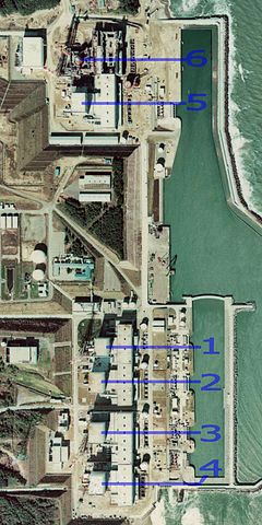
English: Fukushima I Nuclear Power Plant. Medium crop showing reactors labeled 1 to 5 and site for reactor 6. North is up.
日本語: 福島第一原子力発電所。 |
| วันที่ | |
| แหล่งที่มา | http://w3land.mlit.go.jp/cgi-bin/WebGIS2/WC_AirPhoto.cgi?IT=p&DT=n&PFN=CTO-75-30&PCN=C29B&IDX=21 |
| ผู้สร้างสรรค์ | Ministry of Land, Infrastructure, Transport and Tourism |
| เวอร์ชันอื่น |
|
| ตำแหน่งที่ตั้งกล้อง | | ภาพนี้และภาพอื่น ๆ ณ สถานที่เดียวกันที่ OpenStreetMap |
|---|
การอนุญาตใช้สิทธิ

|
กระทรวงที่ดิน โครงสร้างพื้นฐาน การขนส่ง และการท่องเที่ยว ซึ่งเป็นผู้ถือลิขสิทธิ์ของไฟล์นี้ อนุญาตให้นำไฟล์นี้ไปใช้ได้ในทุกวัตถุประสงค์ รวมไปถึงการทำซ้ำ การนำไฟล์นี้ไปใช้ในการสร้างไฟล์ใหม่ การใช้เพื่อการค้า และการใช้อื่น ๆ โดยมีเงื่อนไขว่า ต้องระบุชื่อผู้ถือลิขสิทธิ์ของไฟล์นี้อย่างเหมาะสมเมื่อนำไฟล์นี้ไปใช้ |
การแสดงที่มา:
Copyright © National Land Image Information (Color Aerial Photographs), Ministry of Land, Infrastructure, Transport and Tourism
|
 |
This image is copyrighted by the Ministry of Land, Infrastructure, Transport and Tourism of Japan. For terms of use, see the stipulation to use of National Land Information (in Japanese) and message from MLIT (in Japanese and English). When you display this image on an article, include the following phrase in the description: "Made based on National Land Image Information (Color Aerial Photographs), Ministry of Land, Infrastructure, Transport and Tourism".
|
ประวัติไฟล์
คลิกวันที่/เวลาเพื่อดูไฟล์ที่ปรากฏในขณะนั้น
| วันที่/เวลา | รูปย่อ | ขนาด | ผู้ใช้ | ความเห็น | |
|---|---|---|---|---|---|
| ปัจจุบัน | 06:54, 16 มีนาคม 2554 | | 800 × 1,600 (248 กิโลไบต์) | 84user | =={{int:filedesc}}== {{Information |Description={{en|1=Fukushima I Nuclear Power Plant. Medium crop showing reactors labeled 1 to 5 and site for reactor 6. North is up.}} {{ja|1=[[:ja:福島第一原子力発電所| |
หน้าที่มีภาพนี้
หน้าต่อไปนี้ โยงมาที่ภาพนี้:
การใช้ไฟล์ข้ามโครงการ
วิกิอื่นต่อไปนี้ใช้ไฟล์นี้:
- การใช้บน ar.wikipedia.org
- การใช้บน ast.wikipedia.org
- การใช้บน be-tarask.wikipedia.org
- การใช้บน ca.wikipedia.org
- การใช้บน cs.wikipedia.org
- การใช้บน cv.wikipedia.org
- การใช้บน de.wikipedia.org
- การใช้บน de.wikinews.org
- การใช้บน en.wikipedia.org
- การใช้บน en.wikibooks.org
- การใช้บน es.wikipedia.org
- การใช้บน fi.wikipedia.org
- การใช้บน fr.wikipedia.org
- การใช้บน gl.wikipedia.org
- การใช้บน he.wikipedia.org
- การใช้บน hi.wikipedia.org
- การใช้บน ja.wikipedia.org
- การใช้บน ko.wikipedia.org
- การใช้บน ko.wikinews.org
- การใช้บน ms.wikipedia.org
- การใช้บน nl.wikipedia.org
- การใช้บน pl.wikipedia.org
- การใช้บน pt.wikipedia.org
- การใช้บน rm.wikipedia.org
- การใช้บน ru.wikipedia.org
- การใช้บน sq.wikinews.org
- การใช้บน ta.wikipedia.org
- การใช้บน zh.wikipedia.org