
ไฟล์:China-Inner-Mongolia.png
ไม่มีภาพที่มีรายละเอียดสูงกว่านี้
China-Inner-Mongolia.png (268 × 218 พิกเซล, ขนาดไฟล์: 15 กิโลไบต์, ชนิดไมม์: image/png)
| รูปภาพหรือไฟล์เสียงนี้ ต้นฉบับอยู่ที่ คอมมอนส์ รายละเอียดด้านล่าง เป็นข้อความที่แสดงผลจาก ไฟล์ต้นฉบับในคอมมอนส์
|
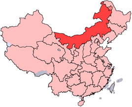
en: Location of Inner Mongolia Autonomous Region in the People's Republic of China. See Locator maps of province-level divisions of the People's Republic of China for more information. The striped area is nominally part of Inner Mongolia, but it is administered by Daxing'anling Prefecture of Heilongjiang Province.
zh: 内蒙古自治區在中華人民共和國的位置。另見Locator maps of province-level divisions of the People's Republic of China。加斜杠的地區由黑龍江省大興安嶺地區所管轄,僅在名義上為内蒙古的一部分。

|
อนุญาตให้คัดลอก แจกจ่ายและ/หรือดัดแปรเอกสารนี้ภายใต้เงื่อนไขของสัญญาอนุญาตเอกสารเสรีของกนู รุ่น 1.2 หรือรุ่นใด ๆ นับจากนี้ที่ออกโดยมูลนิธิซอฟต์แวร์เสรี โดยไม่มีส่วนใดห้ามแก้ไข ไม่มีข้อความปกหน้าและปกหลัง สำเนาของสัญญาอนุญาตรวมอยู่ในส่วนชื่อ สัญญาอนุญาตเอกสารเสรีของกนู |
| ไฟล์นี้อยู่ภายใต้สัญญาอนุญาต ครีเอทีฟคอมมอนส์ แบบแสดงที่มา-อนุญาตแบบเดียวกัน 3.0 ต้นฉบับ | ||
| ||
| ป้ายแสดงสถานะลิขสิทธิ์นี้ถูกเพิ่มเพื่อให้เป็นไปตามการเปลี่ยนแปลงสัญญาอนุญาตของมูลนิธิวิกิมีเดีย จาก GFDL ไปยัง GFDL ควบคู่กับ CC-BY-SA 3.0 |
ประวัติไฟล์
คลิกวันที่/เวลาเพื่อดูไฟล์ที่ปรากฏในขณะนั้น
| วันที่/เวลา | รูปย่อ | ขนาด | ผู้ใช้ | ความเห็น | |
|---|---|---|---|---|---|
| ปัจจุบัน | 21:44, 15 กรกฎาคม 2548 | | 268 × 218 (15 กิโลไบต์) | Schaengel89~commonswiki | transparent background |
| 04:42, 5 มิถุนายน 2548 |  | 268 × 218 (9 กิโลไบต์) | Ran | '''en''': Location of Inner Mongolia in the People's Republic of China. See Category:Locator maps of province-level divisions of the People's Republic of China for more information. '''zh''': 内蒙古自治區在中華人民共和國的位置。另 |
หน้าที่มีภาพนี้
ไม่มีหน้าใดโยงมาที่ภาพนี้
การใช้ไฟล์ข้ามโครงการ
วิกิอื่นต่อไปนี้ใช้ไฟล์นี้:
- การใช้บน da.wikipedia.org
- การใช้บน de.wikipedia.org
- การใช้บน en.wikipedia.org
- Wikipedia:WikiProject Chinese provinces/Locator maps
- Fengzhen
- Yin Mountains
- Hanggai (village)
- Tengger Desert
- Liaobei
- Dolon Nor
- Oroqen Autonomous Banner
- Solun, Horqin Right Front Banner
- Khalkhin Gol
- Bailingmiao
- Dongsheng District
- Chifeng Yulong Airport
- Hulunbuir Hailar Airport
- Tongliao Airport
- Xilinhot Airport
- Template:InnerMongolia-geo-stub
- Lang Mountains
- Tsondol
- Xar Moron River
- Honggor Sum, Siziwang Banner
- Baochang, Taibus Banner
- Hobor
- Honggor Sum, Sonid Left Banner
- Hongort
- Shangdu County
- Xuejiawan, Jungar Banner
- Dashuigou Formation
- Bayin-Gobi Formation
- Jalaid Banner
- Hexigten Banner
- Horinger County
- Xincheng, Hohhot
- Wuyuan County, Inner Mongolia
ดูการใช้ข้ามโครงการเพิ่มเติมของไฟล์นี้