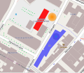
ไฟล์:2011 Oslo attacks map.svg

ขนาดของตัวอย่าง PNG นี้ของไฟล์ SVG นี้: 603 × 524 พิกเซล ความละเอียดอื่น: 276 × 240 พิกเซล | 552 × 480 พิกเซล | 884 × 768 พิกเซล | 1,178 × 1,024 พิกเซล | 2,357 × 2,048 พิกเซล
ดูภาพที่มีความละเอียดสูงกว่า ((ไฟล์ SVG, 603 × 524 พิกเซล, ขนาดไฟล์: 516 กิโลไบต์))
ประวัติไฟล์
คลิกวันที่/เวลาเพื่อดูไฟล์ที่ปรากฏในขณะนั้น
| วันที่/เวลา | รูปย่อ | ขนาด | ผู้ใช้ | ความเห็น | |
|---|---|---|---|---|---|
| ปัจจุบัน | 17:36, 23 กรกฎาคม 2554 |  | 603 × 524 (516 กิโลไบต์) | Beao | Minor positioning. |
| 17:34, 23 กรกฎาคม 2554 |  | 603 × 524 (516 กิโลไบต์) | Beao | {{Information |Description={{en|1=Map over the ''2011 Oslo attacks''. <br>''Red building'': Government building.<br>''Orange area'': Position of the remains of the exploded car.<br>''Blue building'': Oil Ministry building.}} |Source=*[[:File:2011_Oslo_att |
หน้าที่มีภาพนี้
หน้าต่อไปนี้ โยงมาที่ภาพนี้:
การใช้ไฟล์ข้ามโครงการ
วิกิอื่นต่อไปนี้ใช้ไฟล์นี้:
- การใช้บน be-tarask.wikipedia.org
- การใช้บน be.wikipedia.org
- การใช้บน bg.wikipedia.org
- การใช้บน bs.wikipedia.org
- การใช้บน ckb.wikipedia.org
- การใช้บน cs.wikipedia.org
- การใช้บน da.wikipedia.org
- การใช้บน eo.wikipedia.org
- การใช้บน eu.wikipedia.org
- การใช้บน fa.wikipedia.org
- การใช้บน fi.wikipedia.org
- การใช้บน fr.wikipedia.org
- การใช้บน hr.wikipedia.org
- การใช้บน hy.wikipedia.org
- การใช้บน it.wikipedia.org
- การใช้บน ja.wikipedia.org
- การใช้บน ko.wikipedia.org
- การใช้บน la.wikipedia.org
- การใช้บน mzn.wikipedia.org
- การใช้บน pl.wikipedia.org
- การใช้บน pt.wikipedia.org
- การใช้บน ru.wikipedia.org
- การใช้บน ru.wikinews.org
- การใช้บน simple.wikipedia.org
- การใช้บน sr.wikipedia.org
- การใช้บน uk.wikipedia.org
- การใช้บน www.wikidata.org
- การใช้บน zh.wikipedia.org
