
ไฟล์:Three Kingdoms of Korea Map.png
ดูภาพที่มีความละเอียดสูงกว่า (658 × 827 พิกเซล, ขนาดไฟล์: 30 กิโลไบต์, ชนิดไมม์: image/png)
| รูปภาพหรือไฟล์เสียงนี้ ต้นฉบับอยู่ที่ คอมมอนส์ รายละเอียดด้านล่าง เป็นข้อความที่แสดงผลจาก ไฟล์ต้นฉบับในคอมมอนส์
|
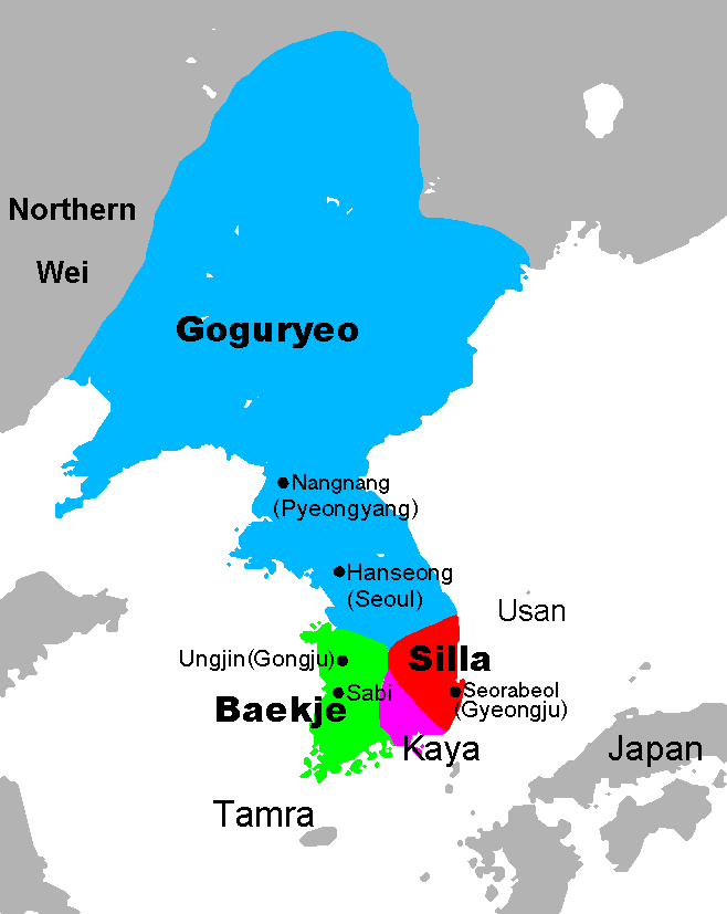
Map of the Three Kingdoms of Korea, at the end of the 5th century, with the largest expansion of Goguryeo. Hanseong was initially the capital of Baekje. Note that the spellings of the countries and cities may differ significantly in different sources.

|
ภาพแผนที่ทางประวัติศาสตร์นี้ ควรจะถูกสร้างใหม่เป็นกราฟิกส์เวกเตอร์ ซึ่งมีข้อดีอีกหลายประการ ดูเพิ่มเติมที่คอมมอนส์:สื่อต้องการเก็บกวาดสำหรับสารสนเทศเพิ่มเติม หากภาพนี้มีในรูปแบบกราฟิกส์เวกเตอร์อยู่แล้ว กรุณาอัปโหลดและแทนที่แม่แบบนี้ด้วย
{{vector version available|ชื่อภาพใหม่}}
แนะนำเป็นอย่างยิ่งให้ตั้งชื่อไฟล์เวกเตอร์ใหม่นั้นในรูปแบบ "Three Kingdoms of Korea Map.svg" แล้วใส่แม่แบบ Vector version available (หรือ Vva) ซึ่งไม่ต้องใช้พารามิเตอร์ ชื่อภาพใหม่ |
Map data from [1] archive copy at the Wayback Machine, which is GFDL, modified and map creation by Chris 73.
- Extra borders removed by Kooo.
- See also: Image:Three Kingdoms of Korea blank.png for a blank map.
- The source file is an open office.org file
Used in:
| Licensing:
This image was created by Chris 73. The image is licensed under a dual license; please choose either of the two licenses below as desired. Attribution to Wikipedia or another project of the Wikimedia foundation is required for both licenses if the image is used outside of projects of the Wikimedia foundation. Attribution to me is not required.
ไฟล์นี้อยู่ภายใต้สัญญาอนุญาต ครีเอทีฟคอมมอนส์ แบบแสดงที่มา-อนุญาตแบบเดียวกัน 3.0 ต้นฉบับ การแสดงที่มา: Chris 73 / Wikimedia Commons
"I want to use the image. How do I do that?" You can use this image freely for any purpose, including commercial use, provided that you license it under one of the above licenses. My suggestion is to use the following text:
For privacy reasons please use only "Chris 73" as author. If necessary, please translate the text in your language. For electronic use please include the links in the text as shown, for printed use please print the text as shown. If you use the image I would appreciate it if you would let me know on my talk page, but this is not required as long as you follow one of the above licenses. |

ประวัติไฟล์
คลิกวันที่/เวลาเพื่อดูไฟล์ที่ปรากฏในขณะนั้น
| วันที่/เวลา | รูปย่อ | ขนาด | ผู้ใช้ | ความเห็น | |
|---|---|---|---|---|---|
| ปัจจุบัน | 16:48, 23 กรกฎาคม 2561 | | 658 × 827 (30 กิโลไบต์) | Dddcg | Use Korean's term on Korean article. Correct terms are Gaya(Kaya, Imna) and Tamna |
| 02:04, 19 กรกฎาคม 2561 |  | 658 × 827 (25 กิโลไบต์) | Satoshi Kondo | fixed a former mistake of me | |
| 16:57, 12 มิถุนายน 2561 |  | 658 × 827 (19 กิโลไบต์) | Satoshi Kondo | correction on baekje and silla | |
| 07:41, 4 มกราคม 2556 |  | 658 × 827 (30 กิโลไบต์) | Shibo77 | Corrected locations of Sabi, Ungjin, Northern Wei. Revised Romanisation for Pyeongyang. Contemporary names Nangnang and Seorabeul for modern Pyeongyang and Gyeongju. See Wikimedia Commons talk page. | |
| 22:36, 14 พฤศจิกายน 2553 |  | 658 × 827 (17 กิโลไบต์) | Valentim | Reverted to version as of 06:23, 13 November 2010. Maybee I'm wrong, see User talk:Valentim#Look at the ja:利用者‐会話:トムル#失礼します.. | |
| 20:54, 13 พฤศจิกายน 2553 |  | 658 × 827 (17 กิโลไบต์) | Valentim | Reverted to version as of 13:42, 10 November 2010. That I wanted to tell you: Tamna is all right, Tamra not. But as you admid that Tamra is wrong: Why don't you stop to upload your wrong version? USE THE DISKUSSION! | |
| 13:23, 13 พฤศจิกายน 2553 |  | 658 × 827 (17 กิโลไบต์) | Garam | Reverted to version as of 09:12, 10 November 2010 // Look at the Tamna(korean) | |
| 20:42, 10 พฤศจิกายน 2553 |  | 658 × 827 (17 กิโลไบต์) | Valentim | Reverted to version as of 09:36, 26 September 2010. See w:en:Jeju-do. Do you know why we got discussion pages for? Maybee for cases like this one? | |
| 16:12, 10 พฤศจิกายน 2553 |  | 658 × 827 (17 กิโลไบต์) | Garam | Reverted to version as of 12:14, 2 September 2010 // Oh, my got.. Hey, Do you know what kind korean histroy? | |
| 16:36, 26 กันยายน 2553 |  | 658 × 827 (17 กิโลไบต์) | Valentim | Reverted to version as of 14:56, 2 August 2009. "Tamra" was never a reference name to Jeju-do. |
หน้าที่มีภาพนี้
หน้าต่อไปนี้ โยงมาที่ภาพนี้:
การใช้ไฟล์ข้ามโครงการ
วิกิอื่นต่อไปนี้ใช้ไฟล์นี้:
- การใช้บน af.wikipedia.org
- การใช้บน als.wikipedia.org
- การใช้บน ar.wikipedia.org
- การใช้บน ast.wikipedia.org
- การใช้บน bg.wikipedia.org
- การใช้บน ckb.wikipedia.org
- การใช้บน csb.wikipedia.org
- การใช้บน cs.wikipedia.org
- การใช้บน da.wikipedia.org
- การใช้บน de.wikipedia.org
- การใช้บน en.wikipedia.org
- การใช้บน en.wikibooks.org
- การใช้บน en.wikivoyage.org
- การใช้บน eo.wikipedia.org
- การใช้บน fa.wikipedia.org
- การใช้บน fi.wikipedia.org
- การใช้บน fr.wikipedia.org
- การใช้บน gl.wikipedia.org
- การใช้บน he.wikipedia.org
- การใช้บน hr.wikipedia.org
- การใช้บน id.wikipedia.org
- การใช้บน io.wikipedia.org
- การใช้บน it.wikipedia.org
ดูการใช้ข้ามโครงการเพิ่มเติมของไฟล์นี้